Approximate Location Map
Large Map »
Latitude: 51.7854 / 51°47'7"N
Longitude: -2.1949 / 2°11'41"W
OS Eastings: 386652
OS Northings: 209656
OS Grid: SO866096
Mapcode National: GBR 1M6.3WJ
Mapcode Global: VH94R.XD04
Plus Code: 9C3VQRP4+52
Entry Name: Five Poole Monuments Circa 6 Metres North of North Aisle in Churchyard of the Church of St Mary
Listing Date: 24 August 1990
Grade: II
Source: Historic England
Source ID: 1304463
English Heritage Legacy ID: 133392
ID on this website: 101304463
Location: St Mary's Church, Painswick, Stroud, Gloucestershire, GL6
County: Gloucestershire
District: Stroud
Civil Parish: Painswick
Built-Up Area: Painswick
Traditional County: Gloucestershire
Lieutenancy Area (Ceremonial County): Gloucestershire
Church of England Parish: Painswick St Mary the Virgin
Church of England Diocese: Gloucester
Tagged with: Monument
PAINSWICK NEW STREET
SO 8609 (part)
(south east side)
9/205 Five Poole monuments c.6 m
north of north aisle in
churchyard of the Church
of St Mary
GV II
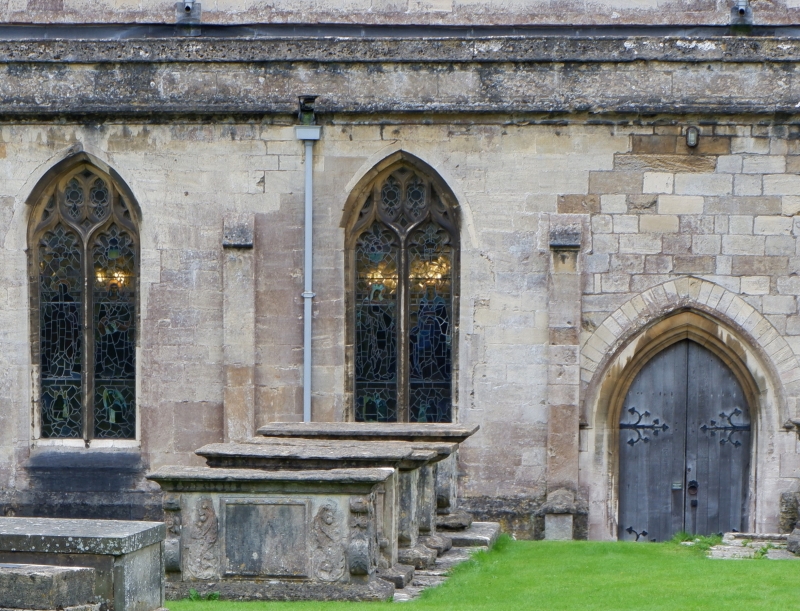
Five chest tombs. Late C17 to late C18. Limestone. Set on a common base,
reading from north to south.
(a) Early C18. Flat table to cavetto mould, lyre ends with cartouches to west
and 3 cherubim to east, bolection mould panel with supporters to north, some
lettering, and cartouche panel to south, all on broad cavetto base. Records
John Poole to north, and 1879 survey gives John Poole 1755, but the design may
be fifty years earlier than this.
(b) Lofty chest tomb, mid to late C18. Flat table to moulded edge, elongated ¼
balusters, all replaced; sunk panels with moulded surrounds east and west,
circular panel with raised moulding within square to north, plain badly worn
panel to south, all on cavetto base. The 1879 survey records William Poole,
1771.
(c) Late C17. Thick moulded table to cyma edge, rounded lyre ends with cartou-
ches, circular cartouche to north, sunk and moulded with embellishment to south,
wide cavetto base. Mainly illegible, but date 1670 decipherable to south side,
and recorded in 1879 survey as Anthony Poole, 1670: also mentions a 1658 date
then visible.
(d) Late C17. Thick moulded table to cyma edge, rounded lyre ends with cartou-
ches, circular panel in cartouche to north and replaced sunk panel to south on
broad cyma base. Not legible, but 1879 survey records John Poole, 1667.
(e) Monument nearest to church. Early C18 or late C17. Broad thick table to
cyma edge, wide lyre ends richly carved; to north is sunk moulded panel with
side panels and some lettering, to the south a rich surround with supporters in
high relief, drapes, and 'green man' heads, some lettering: all on cyma base.
North side includes Anne (Poole), 1701, and south side Richard Poole, 1798, but
the design is certainly of the earlier date.
A very important family group of monuments, all showing the continued weathering
characteristic of the churchyard.
Listing NGR: SO8665209656
External links are from the relevant listing authority and, where applicable, Wikidata. Wikidata IDs may be related buildings as well as this specific building. If you want to add or update a link, you will need to do so by editing the Wikidata entry.


Other nearby listed buildings
