Latitude: 51.0552 / 51°3'18"N
Longitude: -2.2904 / 2°17'25"W
OS Eastings: 379742
OS Northings: 128466
OS Grid: ST797284
Mapcode National: GBR 0VG.PS3
Mapcode Global: FRA 662B.CJD
Plus Code: 9C3V3P45+3R
Entry Name: Pierston House
Listing Date: 3 January 1985
Grade: II
Source: Historic England
Source ID: 1305047
English Heritage Legacy ID: 102975
ID on this website: 101305047
Location: Milton on Stour, Dorset, SP8
County: Dorset
Civil Parish: Gillingham
Traditional County: Dorset
Lieutenancy Area (Ceremonial County): Dorset
Church of England Parish: Milton
Church of England Diocese: Salisbury
Tagged with: House
ST 72 NE GILLINGHAM MILTON-ON-STOUR
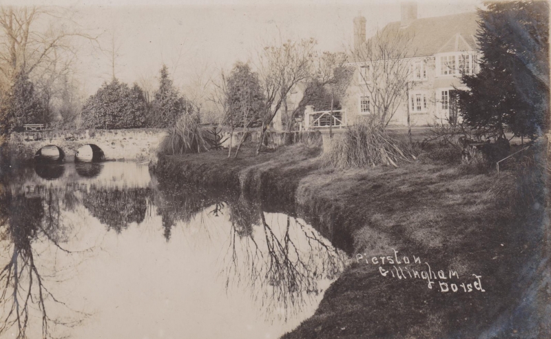
2/136 Pierston House
- II
House, early C19 with later C19 cross-wing left. Rendered walls with
hipped, tiled roof. Brick stack part-way along ridge left and end
rendered stack. Originally symmetrical. 2 storeys, 3 window range.
16-pane sashes. Central panelled door. Flat porch supported on Doric
columns.
Listing NGR: ST7974228466
External links are from the relevant listing authority and, where applicable, Wikidata. Wikidata IDs may be related buildings as well as this specific building. If you want to add or update a link, you will need to do so by editing the Wikidata entry.


Other nearby listed buildings