Latitude: 52.7964 / 52°47'47"N
Longitude: -1.1525 / 1°9'9"W
OS Eastings: 457238
OS Northings: 322428
OS Grid: SK572224
Mapcode National: GBR 8KH.PFP
Mapcode Global: WHDHK.8ZF3
Plus Code: 9C4WQRWW+HX
Entry Name: Rose Farmhouse
Listing Date: 15 March 1984
Grade: II
Source: Historic England
Source ID: 1307303
English Heritage Legacy ID: 189299
ID on this website: 101307303
Location: Hoton, Charnwood, Leicestershire, LE12
County: Leicestershire
District: Charnwood
Civil Parish: Hoton
Traditional County: Leicestershire
Lieutenancy Area (Ceremonial County): Leicestershire
Church of England Parish: Prestwold St Andrew
Church of England Diocese: Leicester
Tagged with: Farmhouse
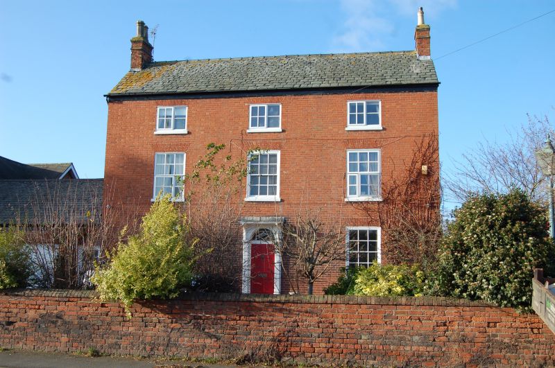
SK 52 SE HOTON LOUGHBOROUGH ROAD
1/41 Rose Farmhouse
GV II
Farmhouse, c1800. Brick with slate roof. 3 storeys, 3 bays. Symmetrical
facade with central doorway, with 6-panelled door and overlight, small bracketted
porch on clustered columns. 12-light sash windows with gauged brick heads.
Gable stacks. Lower wing to rear.
Listing NGR: SK5723822428
External links are from the relevant listing authority and, where applicable, Wikidata. Wikidata IDs may be related buildings as well as this specific building. If you want to add or update a link, you will need to do so by editing the Wikidata entry.


Other nearby listed buildings