Approximate Location Map
Large Map »
Latitude: 51.9118 / 51°54'42"N
Longitude: -0.2085 / 0°12'30"W
OS Eastings: 523321
OS Northings: 225209
OS Grid: TL233252
Mapcode National: GBR J7W.23W
Mapcode Global: VHGP0.B6MS
Plus Code: 9C3XWQ6R+PH
Entry Name: 66, High Street
Listing Date: 18 February 1948
Grade: II
Source: Historic England
Source ID: 1307839
English Heritage Legacy ID: 158068
ID on this website: 101307839
Location: Old Town, Stevenage, Hertfordshire, SG1
County: Hertfordshire
District: Stevenage
Electoral Ward/Division: Old Town
Parish: Non Civil Parish
Built-Up Area: Stevenage
Traditional County: Hertfordshire
Lieutenancy Area (Ceremonial County): Hertfordshire
Church of England Parish: Stevenage Holy Trinity
Church of England Diocese: St.Albans
Tagged with: Building
1.
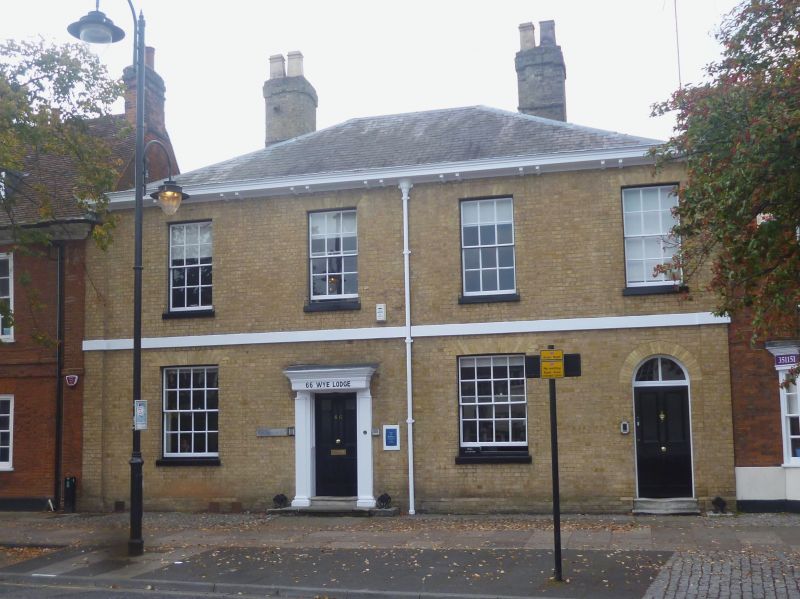
5257 HIGH STREET
(West Side)
-----------
No 66
TL 2325 SW 1/42 18.2.48.
II GV
2.
Early C19 house. Grey brick, hipped Welsh slated roof with wooden cornice on paired
brackets. 2 storeys, pilasters either end, broad stucco bond between floors.
4 rush windows with glazing bars in reveals under flat arches. 2 doors, main 1
of 4 panels in panelled reveal under bracketed hood, formerly with Ionic porch
now removed.
Nos 60 to 72 (even) and 72A form a group.
Listing NGR: TL2332125209
External links are from the relevant listing authority and, where applicable, Wikidata. Wikidata IDs may be related buildings as well as this specific building. If you want to add or update a link, you will need to do so by editing the Wikidata entry.


Other nearby listed buildings
