Approximate Location Map
Large Map »
Latitude: 50.5371 / 50°32'13"N
Longitude: -3.8778 / 3°52'40"W
OS Eastings: 267022
OS Northings: 72499
OS Grid: SX670724
Mapcode National: GBR Q8.VKMQ
Mapcode Global: FRA 27RN.52C
Plus Code: 9C2RG4PC+RV
Entry Name: Range of Farm Buildings Immediately South-East of Combestone Farmhouse
Listing Date: 27 May 1986
Grade: II
Source: Historic England
Source ID: 1308666
English Heritage Legacy ID: 99274
ID on this website: 101308666
Location: Dartmeet, South Hams, Devon, PL20
County: Devon
District: South Hams
Civil Parish: Holne
Traditional County: Devon
Lieutenancy Area (Ceremonial County): Devon
Church of England Parish: Holne St Mary the Virgin
Church of England Diocese: Exeter
Tagged with: Agricultural structure
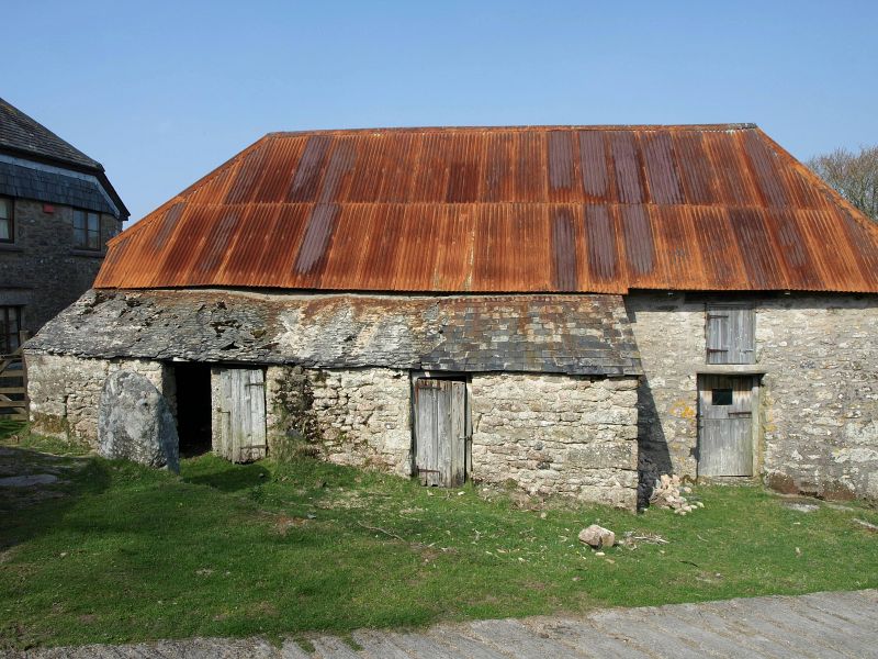
HOLNE -
SX 67 SE
1/175 Range of farm build-
ings immediately
- south-east of
Combestone Farmhouse
GV II
Shippon and adjoining pigsties, store and cowshed. Circa C18. Granite rubble with
large granite quoins. Corrugated iron hipped roof. Shippon with loft above and a
row of pigsties on outer south-west side with a slated lean-to roof. On north-east
side facing farmyard, cattle shelters or linhays originally open fronted but now
blocked left hand with monolithic granite posts. At higher north-west gable end a
loft doorway over slit opening with a dooway to right. At lower south-east end a
blocked opening at centre with flat stone arch, a very small square opening to left
and blocked opening at base of wall, probably the drain. Interior has drain running
down off-centre of stone floor and C19 pegged soft-wood roof. Adjoining at obtuse
angle at lower south-east end a long narrow building with corrugated iron gable-
ended roof, probably a cowshed with a loft over. One small square loft loading
doorway at centre of outer south west side. 2 small square window openings on front
facing yard and widened doorway opening on left for vehicles, with timber lintels.
Possibly built as a detached shippon when the lower end of the house was demolished.
Listing NGR: SX6702272499
External links are from the relevant listing authority and, where applicable, Wikidata. Wikidata IDs may be related buildings as well as this specific building. If you want to add or update a link, you will need to do so by editing the Wikidata entry.


Other nearby listed buildings
