Approximate Location Map
Large Map »
Latitude: 51.646 / 51°38'45"N
Longitude: -0.7294 / 0°43'45"W
OS Eastings: 488009
OS Northings: 194892
OS Grid: SU880948
Mapcode National: GBR D4Z.NF2
Mapcode Global: VHDVZ.9WRL
Plus Code: 9C3XJ7WC+96
Entry Name: Terriers Lodge
Listing Date: 28 June 1973
Grade: II
Source: Historic England
Source ID: 1310582
English Heritage Legacy ID: 46132
ID on this website: 101310582
Location: Terriers, Buckinghamshire, HP13
County: Buckinghamshire
Electoral Ward/Division: Terriers and Amersham Hill
Parish: Non Civil Parish
Built-Up Area: High Wycombe
Traditional County: Buckinghamshire
Lieutenancy Area (Ceremonial County): Buckinghamshire
Church of England Parish: Hazlemere
Church of England Diocese: Oxford
Tagged with: Gatehouse
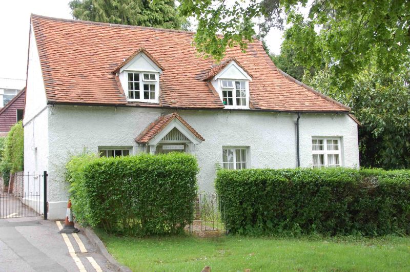
TERRIERS GREEN
1.
963
Terriers Lodge
SU 89 SE 7/311
II GV
2.
C17 or C18. Colour washed roughcast, old tiled roof, 1 storey and attic,
3 casements with glazing bars, 2 gabled casement dormers.
Terriers Lodge forms a group with No 201 Amersham Road.
Listing NGR: SU8800994892
External links are from the relevant listing authority and, where applicable, Wikidata. Wikidata IDs may be related buildings as well as this specific building. If you want to add or update a link, you will need to do so by editing the Wikidata entry.


Other nearby listed buildings
