Approximate Location Map
Large Map »
Latitude: 51.6191 / 51°37'8"N
Longitude: -0.7172 / 0°43'1"W
OS Eastings: 488909
OS Northings: 191922
OS Grid: SU889919
Mapcode National: GBR D5C.KGK
Mapcode Global: VHDW5.JK6N
Plus Code: 9C3XJ79M+J4
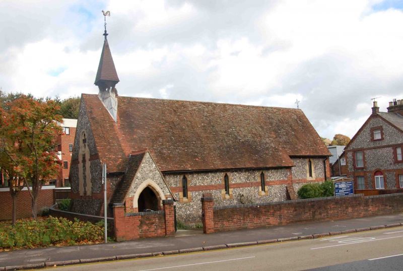
Entry Name: Church of St Anne
Listing Date: 28 June 1973
Grade: II
Source: Historic England
Source ID: 1310642
English Heritage Legacy ID: 46108
ID on this website: 101310642
Location: Wycombe Marsh, Buckinghamshire, HP11
County: Buckinghamshire
Electoral Ward/Division: Ryemead
Parish: Non Civil Parish
Built-Up Area: High Wycombe
Traditional County: Buckinghamshire
Lieutenancy Area (Ceremonial County): Buckinghamshire
Church of England Parish: High Wycombe Saint Anne and Saint Peter
Church of England Diocese: Oxford
Tagged with: Church building
LONDON ROAD
1.
963
(North Side)
Church of St Anne
SU 8891 NE 4/200
GV
2.
Later C19 in Early English style. Flint rubble, red brick and ashlar.
south porch, nave, chancel, west bell cote, north vestry. 1859 by G E Street.
Forms group with the Baptist Church and Nos 559 to 569 (odd).
Listing NGR: SU8890991922
External links are from the relevant listing authority and, where applicable, Wikidata. Wikidata IDs may be related buildings as well as this specific building. If you want to add or update a link, you will need to do so by editing the Wikidata entry.


Other nearby listed buildings
