Approximate Location Map
Large Map »
Latitude: 54.5223 / 54°31'20"N
Longitude: -2.6729 / 2°40'22"W
OS Eastings: 356543
OS Northings: 514319
OS Grid: NY565143
Mapcode National: GBR 9JS4.4N
Mapcode Global: WH81Y.XLCH
Plus Code: 9C6VG8CG+WR
Entry Name: Green Farmhouse with Adjoining Cottage, Barn/Byre Range and Area Wall
Listing Date: 6 February 1968
Grade: II
Source: Historic England
Source ID: 1311133
English Heritage Legacy ID: 74178
ID on this website: 101311133
Location: Westmorland and Furness, Cumbria, CA10
County: Cumbria
District: Eden
Civil Parish: Shap
Built-Up Area: Shap
Traditional County: Westmorland
Lieutenancy Area (Ceremonial County): Cumbria
Church of England Parish: Shap with Swindale St Michael
Church of England Diocese: Carlisle
Tagged with: Farmhouse
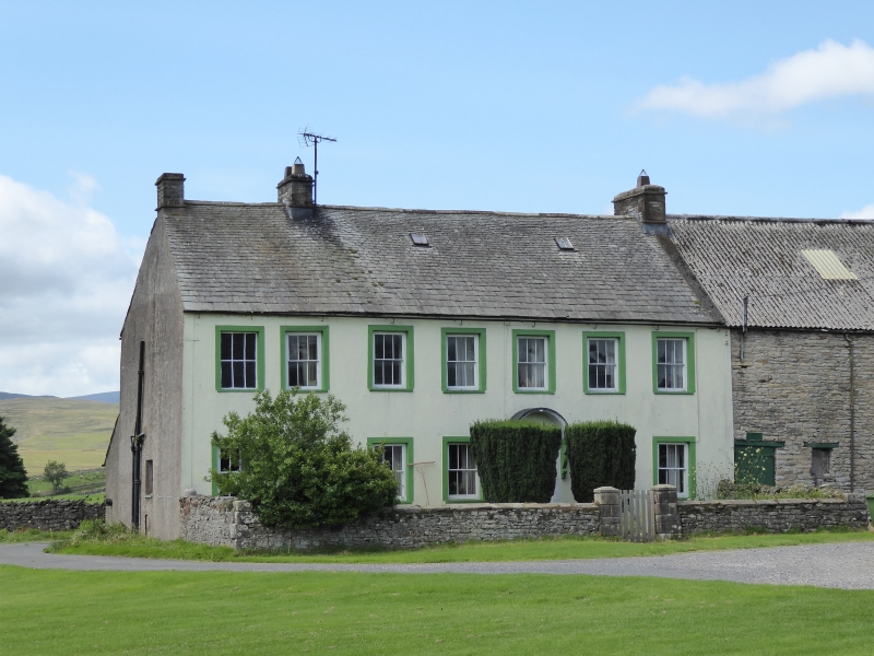
SHAP MAIN STREET
NY 5614/5 (Off West side), Shap
27/163 Green Farmhouse with
adjoining cottage,
6.2.68 barn/byre range, and
area wall
GV II
Farmhouse, cottage (now incorporated into house), and adjoining barn/byre
range. 1703 date (now no longer visible) recorded over house door, with
initials A.W. & W.W. (for Winfell family). House incised stucco; barn/byre
coursed squared rubble with quoins. House roof graduated slate with skylights;
stone coping to north end. Barn/byre roof hipped, corrugated asbestos. All
2 storeys. House originally symmetrical, 5 bays: Central panelled door under
bracketed hood with 2 sashes to either side and 5 above; stone end chimneys.
2-bay former cottage probably had door to ground floor right (now blocked and
rendered over); sash to left and above. Trompe l'oeil window to 1st floor
left. Stone end chimney. All sashes with glazing bars in stone surrounds.
9-bay barn/byre has 2 byre doors and a wagon door, all plank, with windows
between; vent slits to right and above. Area wall to front of house coursed
squared rubble, c.3 ft high, with segmental coping; ashlar gate piers with
pyramidal caps.
Listing NGR: NY5654314319
External links are from the relevant listing authority and, where applicable, Wikidata. Wikidata IDs may be related buildings as well as this specific building. If you want to add or update a link, you will need to do so by editing the Wikidata entry.


Other nearby listed buildings
