Approximate Location Map
Large Map »
Latitude: 54.6501 / 54°39'0"N
Longitude: -1.7441 / 1°44'38"W
OS Eastings: 416606
OS Northings: 528365
OS Grid: NZ166283
Mapcode National: GBR JG8N.6V
Mapcode Global: WHC57.5CQZ
Plus Code: 9C6WM724+28
Entry Name: Former Parish School and Wall Attached
Listing Date: 30 September 1987
Grade: II
Source: Historic England
Source ID: 1311192
English Heritage Legacy ID: 111377
ID on this website: 101311192
Location: High Etherley, County Durham, DL14
County: County Durham
Civil Parish: Etherley
Built-Up Area: Low Etherley
Traditional County: Durham
Lieutenancy Area (Ceremonial County): County Durham
Church of England Parish: Etherley
Church of England Diocese: Durham
Tagged with: Architectural structure
ETHERLEY CHURCH STREET
NZ 12 NE
(East side)
High Etherley
5/12 Former parish
school and wall
attached
GV II
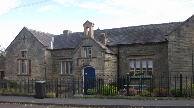
Parish school, now parish hall. Dated 1833. Paid for by Henry Stobart,
coalowner. Extended 1869. Coursed squared sandstone with ashlar dressings,
plinth and quoins; Welsh slate roof. Tudor style. One storey, 5 bays and
long right extension; set-back left wall. Symmetrical main block has central
gabled porch; boarded door, with elaborate iron hinges, in chamfered segmental-
headed surround; stepped dripmould containing blocked 2-light window over panel
with date; coped gable parapet on string; gabled bellcote. 4-light windows
under dripmoulds in flanking bays; outer bays project under gables and have
stepped 4-light windows with transoms to inner lights; cross-shaped vents in
gable peaks. Blank right extension to double door at left end under flat stone
lintel. Low-pitched roofs have moulded kneelers. 2 low ridge chimneys, the
left truncated and the right with double-chamfered coping.
High yard wall set-back at left has gable over boarded door in deeply-chamfered
surround; flat stone coping.
Listing NGR: NZ1660628365
External links are from the relevant listing authority and, where applicable, Wikidata. Wikidata IDs may be related buildings as well as this specific building. If you want to add or update a link, you will need to do so by editing the Wikidata entry.


Other nearby listed buildings
