Latitude: 53.7888 / 53°47'19"N
Longitude: -2.2343 / 2°14'3"W
OS Eastings: 384660
OS Northings: 432520
OS Grid: SD846325
Mapcode National: GBR DSVM.2K
Mapcode Global: WHB83.N178
Plus Code: 9C5VQQQ8+G7
Entry Name: Franciscan Convent and Chapel
Listing Date: 29 September 1977
Last Amended: 19 November 1997
Grade: II
Source: Historic England
Source ID: 1313396
English Heritage Legacy ID: 467246
ID on this website: 101313396
Location: Fulledge, Burnley, Lancashire, BB11
County: Lancashire
District: Burnley
Electoral Ward/Division: Bank Hall
Parish: Non Civil Parish
Built-Up Area: Burnley
Traditional County: Lancashire
Lieutenancy Area (Ceremonial County): Lancashire
Church of England Parish: Burnley St Catherine
Church of England Diocese: Blackburn
BURNLEY
SD8432NE YORKSHIRE STREET 906-1/17/161 (South side) 29/09/77 Nos.59, 61 AND 63 Franciscan Convent and Chapel (Formerly Listed as: TODMORDEN ROAD (West side) St Mary's Presbytery and Chapel to Our Lady of Mercy Convent)
II
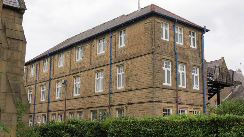
Convent building including chapel. c1870-1930, in 3 builds. Rock-faced sandstone with freestone dressings, slate roofs. Debases Gothic style. L-plan formed by main range on east-west axis parallel to street built in 2 phases, with receding wing added at west end. Mostly 2 storeys with cellars and attics, in 3 portions. (i) The east range, 1:3:1 windows, including the chapel at 1st floor, with a crosswing at its west end and a porch in the angle with this; 3 segmental-headed sashed windows at ground floor, 3 pairs of lancets to the chapel above, an apsidal east end with plate-traceried windows to the chapel, a tall doorway to the porch, and coupled sashed windows on both upper floors of the wing set in a giant 2-centred arch. (ii) A longer range added to this, of similar plan, 5:2 windows, in similar style with 4-pane sashed windows on both floors, those at 1st floor segmental-headed, and a mansard roof with 3 dormers. (iii) The 3-window gabled end of the C20 crosswing, which has casement windows with small-paned overlights. INTERIOR: chapel has gallery at west end, and open roof. Forms group with Roman Catholic Church of St Mary to the west (qv), and with St Mary's Presbytery Todmorden Road (qv) part of which is integrated with this item.
Listing NGR: SD8466032520
External links are from the relevant listing authority and, where applicable, Wikidata. Wikidata IDs may be related buildings as well as this specific building. If you want to add or update a link, you will need to do so by editing the Wikidata entry.


Other nearby listed buildings