Approximate Location Map
Large Map »
Latitude: 53.5597 / 53°33'34"N
Longitude: -1.8116 / 1°48'41"W
OS Eastings: 412578
OS Northings: 407022
OS Grid: SE125070
Mapcode National: GBR HWS8.LP
Mapcode Global: WHCBF.4SMG
Plus Code: 9C5WH55Q+V9
Entry Name: Hinchcliffe Mill Bridge
Listing Date: 4 August 1983
Grade: II
Source: Historic England
Source ID: 1313543
English Heritage Legacy ID: 340298
ID on this website: 101313543
Location: Holmbridge, Kirklees, West Yorkshire, HD9
County: Kirklees
Civil Parish: Holme Valley
Built-Up Area: Holmfirth
Traditional County: Yorkshire
Lieutenancy Area (Ceremonial County): West Yorkshire
Church of England Parish: Holmbridge St David
Church of England Diocese: Leeds
Tagged with: Bridge
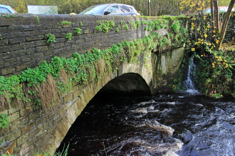
SE 10 NW DOBB LANE
4/71 (Hinchliffe Mill)
Hinchliffe Mill Bridge
II
River bridge. 1839 (datestone). Hammer dressed stone. Single span segmental arched
bridge over River Holme. String course at base of parapet which has recent round
copings (concrete). Keystone to arch on west side has date: 1839.
Listing NGR: SE1257807021
External links are from the relevant listing authority and, where applicable, Wikidata. Wikidata IDs may be related buildings as well as this specific building. If you want to add or update a link, you will need to do so by editing the Wikidata entry.


Other nearby listed buildings
