Approximate Location Map
Large Map »
Latitude: 53.6103 / 53°36'37"N
Longitude: -1.7905 / 1°47'25"W
OS Eastings: 413956
OS Northings: 412656
OS Grid: SE139126
Mapcode National: GBR HVYP.4K
Mapcode Global: WHCB7.GJL4
Plus Code: 9C5WJ665+4Q
Entry Name: 53, 55, Magdale
Listing Date: 4 August 1983
Grade: II
Source: Historic England
Source ID: 1313564
English Heritage Legacy ID: 340427
ID on this website: 101313564
Location: Mag Dale, Kirklees, West Yorkshire, HD9
County: Kirklees
Civil Parish: Holme Valley
Built-Up Area: Holmfirth
Traditional County: Yorkshire
Lieutenancy Area (Ceremonial County): West Yorkshire
Church of England Parish: Honley St Mary
Church of England Diocese: Leeds
Tagged with: Building
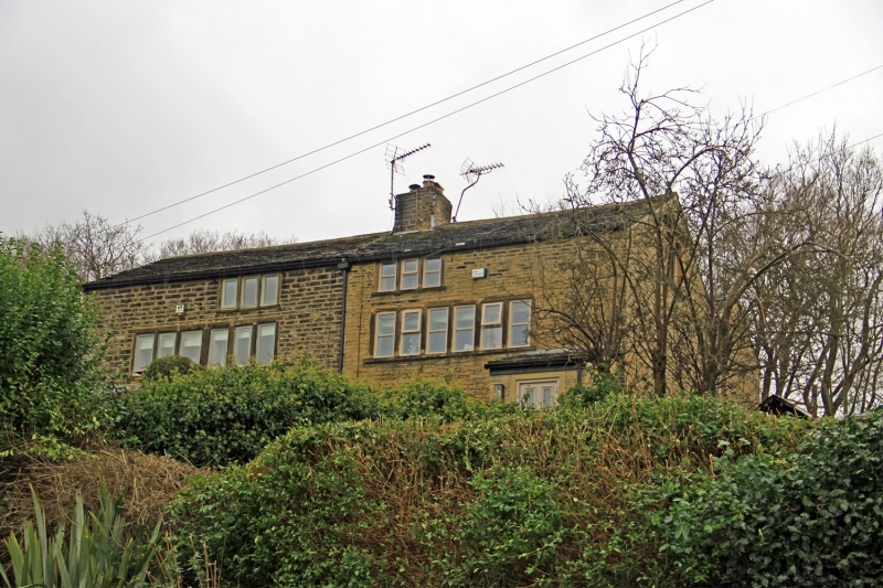
SE 1312 NAGDALE
9/200 (Honley)
Nos 53 and 55
II
Handed pair. Early C19. Hammer dressed stone. Stone slate roof. Three storeys.
South elevation: ground floor altered. Each dwelling has one 6-light stone mullioned
window to first floor and one 3-light window to second floor. To rear is later
extension with pitched roof of no architectural interest.
Listing NGR: SE1395612656
External links are from the relevant listing authority and, where applicable, Wikidata. Wikidata IDs may be related buildings as well as this specific building. If you want to add or update a link, you will need to do so by editing the Wikidata entry.


Other nearby listed buildings
