Approximate Location Map
Large Map »
Latitude: 53.649 / 53°38'56"N
Longitude: -1.7827 / 1°46'57"W
OS Eastings: 414459
OS Northings: 416965
OS Grid: SE144169
Mapcode National: GBR HVZ7.VN
Mapcode Global: WHCB1.LJ9Z
Plus Code: 9C5WJ6X8+HW
Entry Name: 70-78, John William Street
Listing Date: 6 April 1973
Last Amended: 29 September 1978
Grade: II
Source: Historic England
Source ID: 1313875
English Heritage Legacy ID: 340016
ID on this website: 101313875
Location: Newtown, Kirklees, West Yorkshire, HD1
County: Kirklees
Electoral Ward/Division: Newsome
Parish: Non Civil Parish
Built-Up Area: Huddersfield
Traditional County: Yorkshire
Lieutenancy Area (Ceremonial County): West Yorkshire
Church of England Parish: Huddersfield St Peter
Church of England Diocese: Leeds
Tagged with: Building
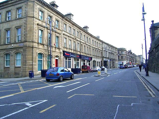
JOHN WILLIAM STREET
1.
5113
(East Side)
Nos 70 to 78 (even)
(formerly listed as
Nos 70, 72, 72A, 74, 74A,
76, 76A and 78)
SE 1416 NW 1/49 6.4.73
II GV
2.
Mid C19. Ashlar sandstone. Sandstone stacks with modillioned cornices. 3
storeys. Modillioned eaves cornice. Continuous moulded sill bands. Moulded
cornice above ground floor. Rusticated quoins. Ground floor has modern shop
fronts (except for upper parts of No , which have fancy glazing bars), but
some fascias
are separated by paired fluted consoles. However, 3 bays at north
end, and one at south, have segment-headed openings with continuous moulded
impost band, and moulded voussoirs: 2 have sashes, with a recessed panel below
them, one has a modern door, and one has double doors with 6 moulded panels
and fanlight. 1st and second floors have six ranges of sashes in moulded surrounds
(shouldered on 1st floor), those on 1st floor having sills on fluted brackets,
cornices and triangular pediments on windows 3, 8, 11 and 15. Chamfered corners
with Brooke Street, and with Wood Street. Brook Street elevation has 10 ranges
of sashes, those on ground floor the same as their counterparts in John William
Street, those on 1st floor with moulded surrounds, those on 2nd floor with
plain surrounds.
Listing NGR: SE1445916965
External links are from the relevant listing authority and, where applicable, Wikidata. Wikidata IDs may be related buildings as well as this specific building. If you want to add or update a link, you will need to do so by editing the Wikidata entry.


Other nearby listed buildings
