Approximate Location Map
Large Map »
Latitude: 53.6831 / 53°40'59"N
Longitude: -1.7359 / 1°44'9"W
OS Eastings: 417542
OS Northings: 420770
OS Grid: SE175207
Mapcode National: GBR JT9V.ZF
Mapcode Global: WHC9W.9PNB
Plus Code: 9C5WM7M7+6M
Entry Name: Calder and Hebble Navigation Cooper Bridge Floodgate
Listing Date: 2 December 1983
Grade: II
Source: Historic England
Source ID: 1314046
English Heritage Legacy ID: 338792
ID on this website: 101314046
Location: Bradley, Calderdale, West Yorkshire, HD5
County: Calderdale
Electoral Ward/Division: Ashbrow
Parish: Non Civil Parish
Built-Up Area: Huddersfield
Traditional County: Yorkshire
Lieutenancy Area (Ceremonial County): West Yorkshire
Church of England Parish: Hartsheadst Peter
Church of England Diocese: Leeds
Tagged with: Architectural structure
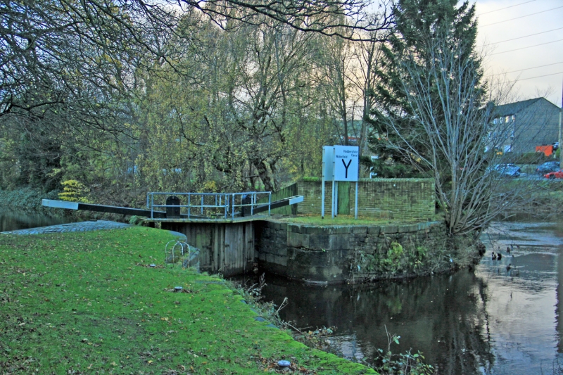
BRIGHOUSE CALDER & HEBBLE NAVIGATION
SE 12 SE
4/43 Cooper Bridge Floodgate
G.V. II
Floodgate from River Calder into Cooper Bridge Cut, late C18. Massive stone
retaining walls with rusticated copings. Shallow access for gates (still
intact).
Listing NGR: SE1754220770
External links are from the relevant listing authority and, where applicable, Wikidata. Wikidata IDs may be related buildings as well as this specific building. If you want to add or update a link, you will need to do so by editing the Wikidata entry.


Other nearby listed buildings
