Latitude: 53.6906 / 53°41'26"N
Longitude: -1.792 / 1°47'31"W
OS Eastings: 413831
OS Northings: 421597
OS Grid: SE138215
Mapcode National: GBR HTXR.TR
Mapcode Global: WHC9V.FHWJ
Plus Code: 9C5WM6R5+75
Entry Name: Cross Base in Churchyard of St Matthews Church
Listing Date: 3 January 1967
Grade: II*
Source: Historic England
Source ID: 1314049
English Heritage Legacy ID: 338807
Also known as: Anglian high cross fragment in the churchyard of St Matthew's Church, Rastrick
ID on this website: 101314049
Location: St Matthew's Church, Rastrick, Calderdale, West Yorkshire, HD6
County: Calderdale
Electoral Ward/Division: Rastrick
Parish: Non Civil Parish
Built-Up Area: Brighouse
Traditional County: Yorkshire
Lieutenancy Area (Ceremonial County): West Yorkshire
Church of England Parish: Rastrick St Matthew
Church of England Diocese: Leeds
Tagged with: High cross
BRIGHOUSE CHURCH STREET, RASTRICK SE 12 SW 3/58 Cross base in Churchyard of St. Matthew's Church 3.1.67 G. V. II*
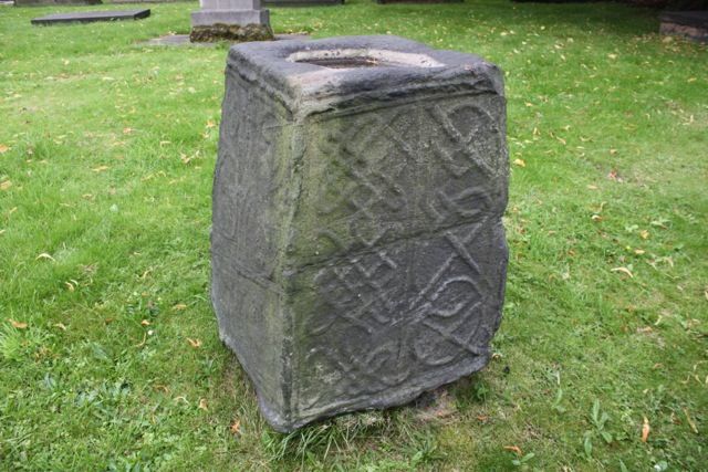
Anglian cross base. c10 or C11. Solid large stone block with 4 tapering sides and indented head for cross shaft (now gone). Each of the 4 faces have moulded edges and carving in relief with foliated vine scroll to 2 sides, one side blind. That fronting street is divided into 2 panels of interlace of geometric character. A rare survival, possibly in its original position when it would have been used as a preaching cross. Of similar character to Walton cross, Hartshead, Spenborough, Kirklees District (q.v.)
Listing NGR: SE1383121596
External links are from the relevant listing authority and, where applicable, Wikidata. Wikidata IDs may be related buildings as well as this specific building. If you want to add or update a link, you will need to do so by editing the Wikidata entry.


Other nearby listed buildings