Approximate Location Map
Large Map »
Latitude: 53.7323 / 53°43'56"N
Longitude: -1.1349 / 1°8'5"W
OS Eastings: 457167
OS Northings: 426556
OS Grid: SE571265
Mapcode National: GBR NTJ8.2T
Mapcode Global: WHDC3.JGS3
Plus Code: 9C5WPVJ8+W2
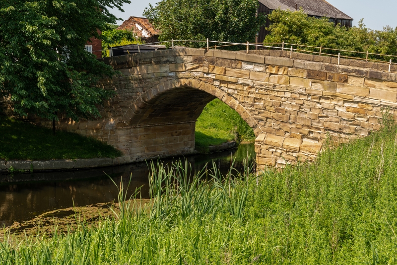
Entry Name: Tankards Bridge
Listing Date: 17 November 1966
Grade: II
Source: Historic England
Source ID: 1316360
English Heritage Legacy ID: 326471
ID on this website: 101316360
Location: West Haddlesey, North Yorkshire, YO8
County: North Yorkshire
District: Selby
Civil Parish: West Haddlesey
Traditional County: Yorkshire
Lieutenancy Area (Ceremonial County): North Yorkshire
Church of England Parish: Haddlesey St John the Baptist
Church of England Diocese: York
Tagged with: Bridge
NORTH YORKSHIRE
SELBY
5342
SE 52 NE WEST HADDLESEY MAIN STREET
4/21 Tankard's Bridge
17.11.66
- II
Canal bridge. Late C18. Sandstone ashlar with cast iron balustrade. Humpbacked
bridge. Central, round-arched opening, low parapet with rounded coping and splayed
ends terminating in round capped piers. Surmounted by low cast-iron balustrade.
Listing NGR: SE5716726556
External links are from the relevant listing authority and, where applicable, Wikidata. Wikidata IDs may be related buildings as well as this specific building. If you want to add or update a link, you will need to do so by editing the Wikidata entry.


Other nearby listed buildings
