Approximate Location Map
Large Map »
Latitude: 53.9431 / 53°56'35"N
Longitude: -2.1131 / 2°6'47"W
OS Eastings: 392673
OS Northings: 449673
OS Grid: SD926496
Mapcode National: GBR FQPV.97
Mapcode Global: WHB7D.H4ZZ
Plus Code: 9C5VWVVP+6Q
Entry Name: Boundary Stone Circa 30 Metres South of Elslack Bridge at Ngr 9266 4967
Listing Date: 31 October 1988
Grade: II
Source: Historic England
Source ID: 1316762
English Heritage Legacy ID: 324450
ID on this website: 101316762
Location: Elslack, North Yorkshire, BD23
County: North Yorkshire
District: Craven
Civil Parish: Elslack
Traditional County: Yorkshire
Lieutenancy Area (Ceremonial County): North Yorkshire
Tagged with: Boundary marker
SD 94 NW ELSLACK ELSLACK LANE
5/72 Boundary Stone c 30m
South of Elslack Bridge
at NGR 9266 4967
II
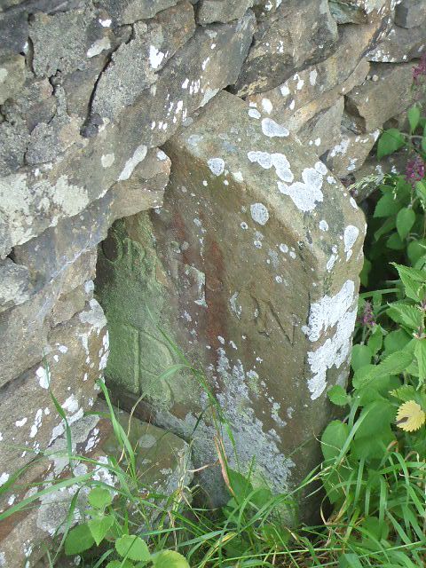
Parish boundary stone, probably C19. Stone slab set edgewise to road, with on
north side "Thornton B" and on south side "Elslack B" (the B appears to be an
alternative from P).
Listing NGR: SD9267349673
External links are from the relevant listing authority and, where applicable, Wikidata. Wikidata IDs may be related buildings as well as this specific building. If you want to add or update a link, you will need to do so by editing the Wikidata entry.


Other nearby listed buildings
