Latitude: 53.8467 / 53°50'47"N
Longitude: -0.4305 / 0°25'49"W
OS Eastings: 503351
OS Northings: 440076
OS Grid: TA033400
Mapcode National: GBR TRFY.LT
Mapcode Global: WHGF4.CK6Y
Plus Code: 9C5XRHW9+MQ
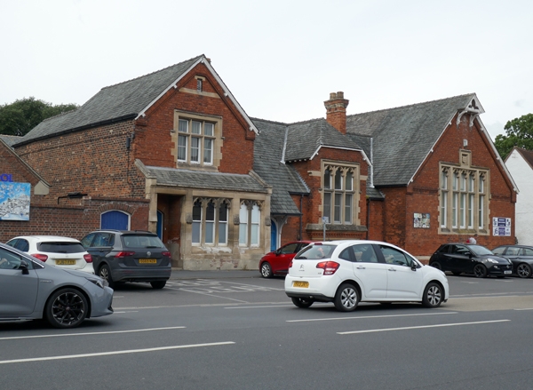
Entry Name: Beverley High School
Listing Date: 21 August 1975
Grade: II
Source: Historic England
Source ID: 1318241
English Heritage Legacy ID: 167403
ID on this website: 101318241
Location: Beverley, East Riding of Yorkshire, HU17
County: East Riding of Yorkshire
Civil Parish: Beverley
Built-Up Area: Beverley
Traditional County: Yorkshire
Lieutenancy Area (Ceremonial County): East Riding of Yorkshire
Church of England Parish: Beverley St Mary
Church of England Diocese: York
Tagged with: School building
This list entry was subject to a Minor Amendment on 11 June 2024 to update the name and address and reformat the text to current standards
TA 0339
9/283
BEVERLEY
NORWOOD (north west side)
Beverley High School
(Formerly listed as St Mary's School)
21.8.75
GV
II
1875. Architects J B and W Atkinson of York. Gothic style structure in red brick with stone dressings. Welsh slate roof. To the right, a broad gabled one storey wing with a ten-light mullion and transom window of stone with cusped headed upper lights, rectangular dripmould. A bell-holder over. The centre has a six-light oriel window with chevron ornament and arched doorway with panelled door under pentice of roof. The left hand wing has a half-hipped gable with a plain six-light mullion and transom window with rectangular dripmould. Stone ground floor pentice with three and two hung sash windows with cusped stone heads. Pointed arch to doorway set back.
Listing NGR: TA0335140076
External links are from the relevant listing authority and, where applicable, Wikidata. Wikidata IDs may be related buildings as well as this specific building. If you want to add or update a link, you will need to do so by editing the Wikidata entry.


Other nearby listed buildings