Approximate Location Map
Large Map »
Latitude: 54.3934 / 54°23'36"N
Longitude: -2.1745 / 2°10'28"W
OS Eastings: 388764
OS Northings: 499787
OS Grid: SD887997
Mapcode National: GBR FK8M.0V
Mapcode Global: WHB51.KTQS
Plus Code: 9C6V9RVG+95
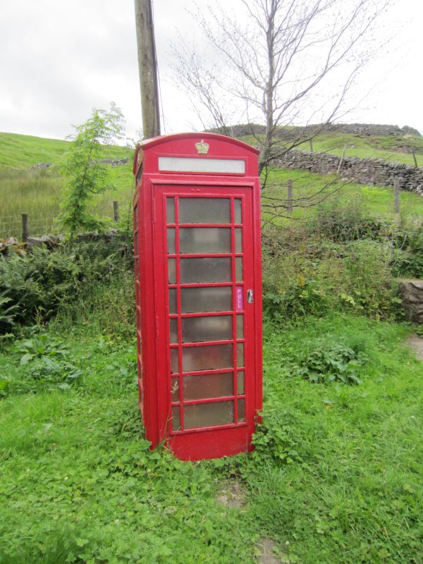
Entry Name: K6 Telephone Kiosk at Junction with Track Up to Skengh Head
Listing Date: 23 March 1989
Grade: II
Source: Historic England
Source ID: 1318275
English Heritage Legacy ID: 322308
ID on this website: 101318275
Location: Angram, North Yorkshire, DL11
County: North Yorkshire
District: Richmondshire
Civil Parish: Muker
Traditional County: Yorkshire
Lieutenancy Area (Ceremonial County): North Yorkshire
Tagged with: K6 telephone box
SD 89 NE MUKER B6270 (west side)
Angram
887 998
13/162 K6 Telephone Kiosk at
junction with track up
to Skengh Head
GV II
Telephone kiosk. Type K6. Designed 1935 by Sir Giles Gilbert Scott. Made
by various contractors. Cast iron. Square kiosk with domed roof. Unper-
forated crowns to top panels and margin glazing to windows and door.
Listing NGR: SD8876499787
External links are from the relevant listing authority and, where applicable, Wikidata. Wikidata IDs may be related buildings as well as this specific building. If you want to add or update a link, you will need to do so by editing the Wikidata entry.


Other nearby listed buildings
