Approximate Location Map
Large Map »
Latitude: 51.1296 / 51°7'46"N
Longitude: -1.8164 / 1°48'59"W
OS Eastings: 412940
OS Northings: 136715
OS Grid: SU129367
Mapcode National: GBR 50M.3L5
Mapcode Global: VHB5J.GVLY
Plus Code: 9C3W45HM+RC
Entry Name: Cartshed and Stables North of Netton Farmhouse
Listing Date: 10 October 1988
Grade: II
Source: Historic England
Source ID: 1318504
English Heritage Legacy ID: 321446
ID on this website: 101318504
Location: Netton, Wiltshire, SP4
County: Wiltshire
Civil Parish: Durnford
Traditional County: Wiltshire
Lieutenancy Area (Ceremonial County): Wiltshire
Church of England Parish: Woodford Valley with Archers Gate
Church of England Diocese: Salisbury
Tagged with: Carriage house
DURNFORD NETTON
SU 13 NW
(west side)
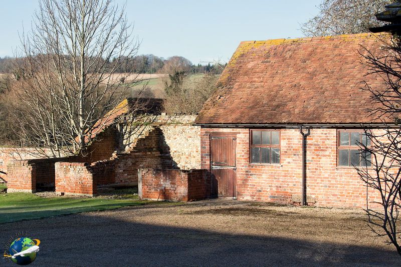
8/135 Cart shed and stables north
of Netton Farmhouse
GV II
Cartshed and stables. Late C18-early C19. Cob and flint with
brick quoins, raised 60cm in various materials, tiled roof. Range
of building including cart shelters backing on to road, with
sliding boarded doors, and on road elevation, one loft door raised
as hipped dormer. Roof hipped. At north end, building returns
down access lane to water meadows, comprising a range of stables,
flint and limestone, also tiled with some concrete lumps. Stable
doors to farmyard. Bronze OS bench mark on outer face. Range
continued as wall to west. Internally, cartshed has queen post
trusses with principal rafters to purlin level. EIIR post box set
in wall of cartshed. Included primarily for group value.
Listing NGR: SU1294036715
External links are from the relevant listing authority and, where applicable, Wikidata. Wikidata IDs may be related buildings as well as this specific building. If you want to add or update a link, you will need to do so by editing the Wikidata entry.


Other nearby listed buildings
