Approximate Location Map
Large Map »
Latitude: 51.533 / 51°31'58"N
Longitude: -0.8631 / 0°51'47"W
OS Eastings: 478952
OS Northings: 182174
OS Grid: SU789821
Mapcode National: GBR C4T.YBN
Mapcode Global: VHDWH.0Q1P
Plus Code: 9C3XG4MP+5P
Entry Name: The Old Smithy
Listing Date: 23 December 1983
Grade: II
Source: Historic England
Source ID: 1319108
English Heritage Legacy ID: 41371
ID on this website: 101319108
Location: Wokingham, Berkshire, RG10
County: Wokingham
Civil Parish: Wargrave
Traditional County: Berkshire
Lieutenancy Area (Ceremonial County): Berkshire
Church of England Parish: Wargrave with Knowl Hill
Church of England Diocese: Oxford
Tagged with: Smithy
WARGRAVE UPPER CULHAM
SU 78 SE
1/22 The Old Smithy
II
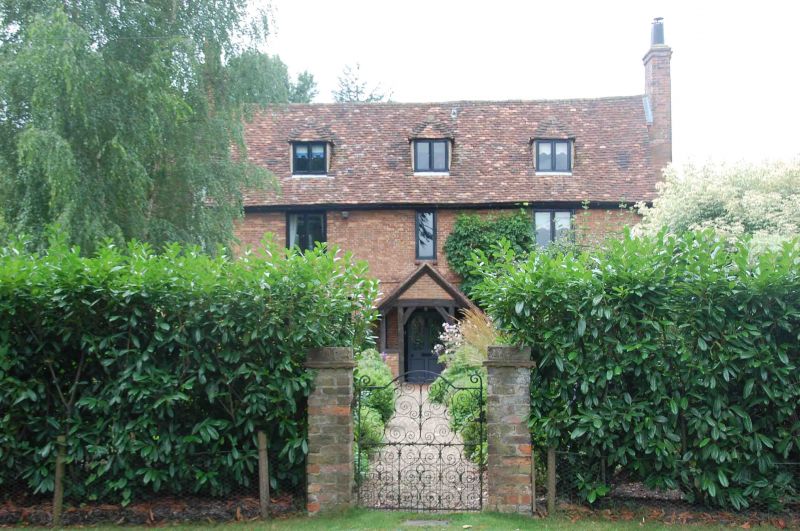
House. C17 or earlier altered C19 and C20. Brick front, first floor string
breaking over windows, ends flint with brick dressings, old tile gabled
roof with dormers 2 large flanking chimneys. T-plan. 2 storeys and attic.
Entrance front:3 bays, hipped dormers and C20 casement windows, central
door in C19 gabled porch.
Listing NGR: SU7895282174
External links are from the relevant listing authority and, where applicable, Wikidata. Wikidata IDs may be related buildings as well as this specific building. If you want to add or update a link, you will need to do so by editing the Wikidata entry.


Other nearby listed buildings
