Approximate Location Map
Large Map »
Latitude: 51.3806 / 51°22'50"N
Longitude: -1.1444 / 1°8'39"W
OS Eastings: 459640
OS Northings: 164961
OS Grid: SU596649
Mapcode National: GBR 93Q.CHB
Mapcode Global: VHCZN.3KVH
Plus Code: 9C3W9VJ4+66
Entry Name: Harris Tomb Aproximately 12 Metres to South West of Tower of Church of St Mary
Listing Date: 10 November 1983
Grade: II
Source: Historic England
Source ID: 1319500
English Heritage Legacy ID: 39503
ID on this website: 101319500
Location: St Mary's Church, Aldermaston, West Berkshire, RG7
County: West Berkshire
Civil Parish: Aldermaston
Traditional County: Berkshire
Lieutenancy Area (Ceremonial County): Berkshire
Church of England Parish: Aldermaston
Church of England Diocese: Oxford
Tagged with: Tomb
ALDERMASTON CHURCH ROAD (south side)
SU 56 SE
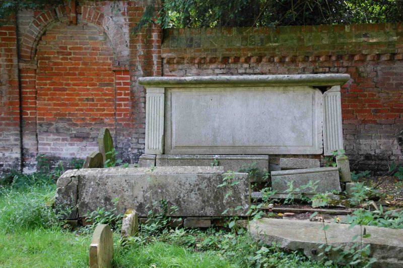
6/28 Harris Tomb Approximately
12 Metres To South-West Of
Tower Of Church Of St Mary
GV II
Chest tomb. Circa 1812. Ashlar. Moulded base and top, fluted corner balusters
Inscribed:............ Harris. d. 1812.
Listing NGR: SU5964064961
External links are from the relevant listing authority and, where applicable, Wikidata. Wikidata IDs may be related buildings as well as this specific building. If you want to add or update a link, you will need to do so by editing the Wikidata entry.


Other nearby listed buildings
