Approximate Location Map
Large Map »
Latitude: 52.7547 / 52°45'16"N
Longitude: -2.2298 / 2°13'47"W
OS Eastings: 384587
OS Northings: 317477
OS Grid: SJ845174
Mapcode National: GBR 17C.72Q
Mapcode Global: WHBF4.Q1D0
Plus Code: 9C4VQQ3C+V3
Entry Name: Smithy Cottage
Listing Date: 10 January 1972
Grade: II
Source: Historic England
Source ID: 1319809
English Heritage Legacy ID: 442884
ID on this website: 101319809
Location: Church Eaton, Stafford, Staffordshire, ST20
County: Staffordshire
District: Stafford
Civil Parish: Church Eaton
Traditional County: Staffordshire
Lieutenancy Area (Ceremonial County): Staffordshire
Church of England Parish: Church Eaton St Editha
Church of England Diocese: Lichfield
Tagged with: Cottage
This entry was subject to a Minor Amendment on 5 May 2017.
SJ 81 NW
8/6A
CHURCH EATON
High Street
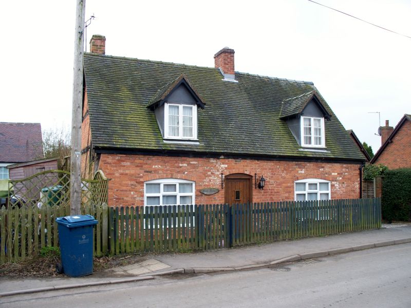
Smithy Cottage
(Formerly listed as Smithy Cottage, CHURCH EATON)
II
Probably medieval. One storey and attic. Cruck construction with crucks exposed at one end; brick front of later date with two windows and a door; modern tile roof with two gabled dormer.
External links are from the relevant listing authority and, where applicable, Wikidata. Wikidata IDs may be related buildings as well as this specific building. If you want to add or update a link, you will need to do so by editing the Wikidata entry.


Other nearby listed buildings
