Latitude: 51.4949 / 51°29'41"N
Longitude: -2.5053 / 2°30'18"W
OS Eastings: 365020
OS Northings: 177452
OS Grid: ST650774
Mapcode National: GBR CX2.4Y
Mapcode Global: VH88H.JPFC
Plus Code: 9C3VFFVV+XV
Entry Name: Cleeve Hill Farmhouse
Listing Date: 15 July 1981
Last Amended: 21 December 1981
Grade: II
Source: Historic England
Source ID: 1320043
English Heritage Legacy ID: 28799
ID on this website: 101320043
Location: Mangotsfield, South Gloucestershire, BS16
County: South Gloucestershire
Civil Parish: Downend and Bromley Heath
Built-Up Area: Bristol
Traditional County: Gloucestershire
Lieutenancy Area (Ceremonial County): Gloucestershire
Church of England Parish: Downend
Church of England Diocese: Bristol
Tagged with: Farmhouse
In the entry for
2/195 EX-MANGOTSFIELD UD OAKDALE AVENUE -
Nos 1 and 2
Cleevehill Farmhouse
The address shall be amended to read
OAKDALE COURT
Cleevehill Farmhouse
(Nos 1 and 2)
------------------------------------
In the following item:-
2/195 EX-MANGOTSFIELD UD OAKDALE AVENUE
Nos 1 and 2
Cleevehill Farmhouse
the address shall be amended to read:-
OAKDALE COURT
Nos 1 and 2
Cleeve Hill Farmhouse
------------------------------------
1.
5118 EX-MANGOTSFIELD UD OAKDALE AVENUE
Nos 1 and 2
Cleevehill Farmhouse
ST 67 NE 2/195
II
2.
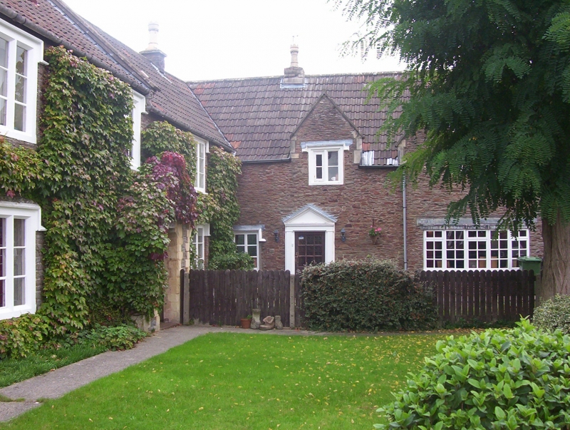
Circa 1700-1720 with alterations and later additions. 'L' shaped building
in pennant stone rubble with attached barn at right angles to right (qv), pantile
roofs. Right hand wing of farmhouse has one large and one small gable to front
and rear, 2-light stone mullioned casement with drip mould in each gable (ogee
moulded, rebated, type). On ground floor the left hand window is a 2-light
casement with a wooden drip (possibly C20), other ground floor openings modern.
Left hand wing has one C20 wooden casement on each floor (wood label on ground
floor) and later 2 window extension to left with chamfered mullions and gabled
stone porch. A short range of pantile roofed garages (former cow-stalls) connects
farmhouse to barn but are not of special interest.
Listing NGR: ST6502077452
External links are from the relevant listing authority and, where applicable, Wikidata. Wikidata IDs may be related buildings as well as this specific building. If you want to add or update a link, you will need to do so by editing the Wikidata entry.


Other nearby listed buildings