Latitude: 51.5384 / 51°32'18"N
Longitude: -2.3962 / 2°23'46"W
OS Eastings: 372620
OS Northings: 182246
OS Grid: ST726822
Mapcode National: GBR JZ.GCZ7
Mapcode Global: VH95T.FL3H
Plus Code: 9C3VGJQ3+9G
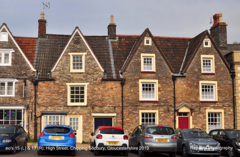
Entry Name: 15, High Street
Listing Date: 17 September 1952
Grade: II*
Source: Historic England
Source ID: 1320901
English Heritage Legacy ID: 34102
ID on this website: 101320901
Location: Chipping Sodbury, South Gloucestershire, BS37
County: South Gloucestershire
Civil Parish: Sodbury
Built-Up Area: Chipping Sodbury
Traditional County: Gloucestershire
Lieutenancy Area (Ceremonial County): Gloucestershire
Church of England Parish: Chipping Sodbury St John the Baptist
Church of England Diocese: Gloucester
Tagged with: Building
ST 7282 SE SODBURY HIGH STREET
5/55 (north side)
17.9.52 No 15
GV
II*
Early-mid C17. Rubble. Modern tiled roof. Two storeys and gabled attic. One
window, glazing bar sashes. Altered ground floor. Wide passage entrance to right.
Listing NGR: ST7262082246
External links are from the relevant listing authority and, where applicable, Wikidata. Wikidata IDs may be related buildings as well as this specific building. If you want to add or update a link, you will need to do so by editing the Wikidata entry.


Other nearby listed buildings