Approximate Location Map
Large Map »
Latitude: 51.9265 / 51°55'35"N
Longitude: -0.5442 / 0°32'39"W
OS Eastings: 500202
OS Northings: 226337
OS Grid: TL002263
Mapcode National: GBR G4L.18P
Mapcode Global: VHFR5.JT5Z
Plus Code: 9C3XWFG4+J8
Entry Name: The Plough Public House
Listing Date: 26 September 1980
Grade: II
Source: Historic England
Source ID: 1321355
English Heritage Legacy ID: 35918
ID on this website: 101321355
Location: Wingfield, Central Bedfordshire, LU7
County: Central Bedfordshire
Civil Parish: Chalgrave
Built-Up Area: Tebworth
Traditional County: Bedfordshire
Lieutenancy Area (Ceremonial County): Bedfordshire
Church of England Parish: Chalgrave
Church of England Diocese: St.Albans
Tagged with: Pub Thatched pub
1.
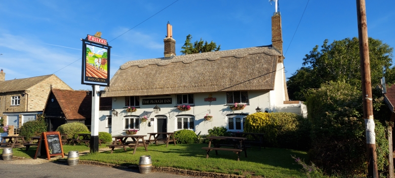
5125 CHALGRAVE TEBWORTH ROAD
(north side)
Wingfield
The Plough Public House
TL 02 NW 22/70
II
2.
C18, altered. Colour washed brick. Two storeys. Thatched roof. Three leaded
casements, around floor cambered relieving arches.
Listing NGR: TL0020226337
External links are from the relevant listing authority and, where applicable, Wikidata. Wikidata IDs may be related buildings as well as this specific building. If you want to add or update a link, you will need to do so by editing the Wikidata entry.


Other nearby listed buildings
