Approximate Location Map
Large Map »
Latitude: 52.0287 / 52°1'43"N
Longitude: -0.4944 / 0°29'39"W
OS Eastings: 503388
OS Northings: 237772
OS Grid: TL033377
Mapcode National: GBR G39.MV9
Mapcode Global: VHFQT.C8ZM
Plus Code: 9C4X2GH4+F6
Entry Name: Church Hall
Listing Date: 17 July 1951
Grade: II
Source: Historic England
Source ID: 1321447
English Heritage Legacy ID: 37387
ID on this website: 101321447
Location: Ampthill, Central Bedfordshire, MK45
County: Central Bedfordshire
Civil Parish: Ampthill
Built-Up Area: Ampthill
Traditional County: Bedfordshire
Lieutenancy Area (Ceremonial County): Bedfordshire
Church of England Parish: Ampthill
Church of England Diocese: St.Albans
Tagged with: Church hall
1.
774 DUNSTABLE STREET
(East Side)
Church Hall
TL 0337 1/61 17.7.51
II
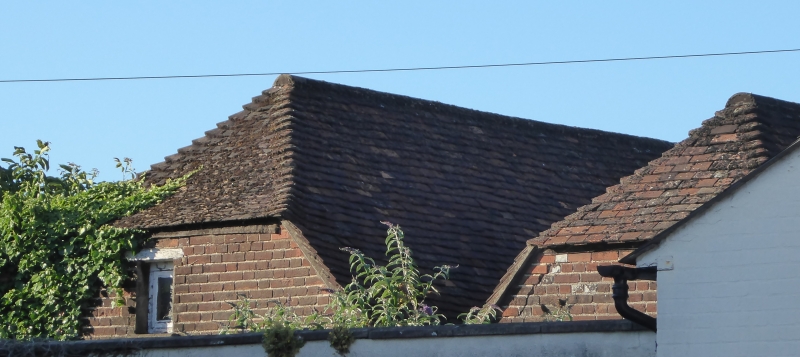
2.
1759. Twin-gabled one storey hall of red brick with semi-hipped tile roof
of 'M' shape. 4 windows (casements reglazed). Original 4-panel door beneath
hood with shaped brackets.
Listing NGR: TL0338837772
External links are from the relevant listing authority and, where applicable, Wikidata. Wikidata IDs may be related buildings as well as this specific building. If you want to add or update a link, you will need to do so by editing the Wikidata entry.


Other nearby listed buildings
