Approximate Location Map
Large Map »
Latitude: 52.193 / 52°11'34"N
Longitude: -0.5117 / 0°30'41"W
OS Eastings: 501831
OS Northings: 256019
OS Grid: TL018560
Mapcode National: GBR G1B.HGS
Mapcode Global: VHFQ1.24VN
Plus Code: 9C4X5FVQ+68
Entry Name: Queens Head Public House
Listing Date: 27 August 1987
Grade: II
Source: Historic England
Source ID: 1321519
English Heritage Legacy ID: 37032
ID on this website: 101321519
Location: Milton Ernest, Bedford, Bedfordshire, MK44
County: Bedford
Civil Parish: Milton Ernest
Built-Up Area: Milton Ernest
Traditional County: Bedfordshire
Lieutenancy Area (Ceremonial County): Bedfordshire
Church of England Parish: Milton Ernest
Church of England Diocese: St.Albans
Tagged with: Pub
MILTON ERNEST RUSHDEN ROAD
TL 0156
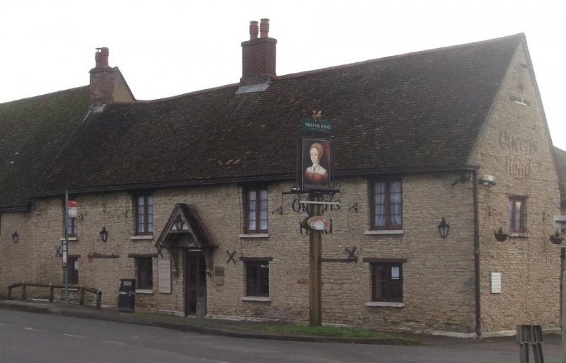
23/262 Queens Head Public House
-
GV II
C18 pair of cottages converted into single unit as public house. Colourwashed
coursed limestone rubble, old clay tile roof. Two storeys. Each floor has
four modern casements in original openings. Original front doors now blocked.
C19 gabled doorhood on elongated brackets.
Listing NGR: TL0183156019
External links are from the relevant listing authority and, where applicable, Wikidata. Wikidata IDs may be related buildings as well as this specific building. If you want to add or update a link, you will need to do so by editing the Wikidata entry.


Other nearby listed buildings
