Approximate Location Map
Large Map »
Latitude: 51.9908 / 51°59'26"N
Longitude: -0.6207 / 0°37'14"W
OS Eastings: 494804
OS Northings: 233384
OS Grid: SP948333
Mapcode National: GBR F2C.5W5
Mapcode Global: VHFQY.6765
Plus Code: 9C3XX9RH+8P
Entry Name: Staunton House
Listing Date: 16 March 1987
Grade: II
Source: Historic England
Source ID: 1321692
English Heritage Legacy ID: 38197
ID on this website: 101321692
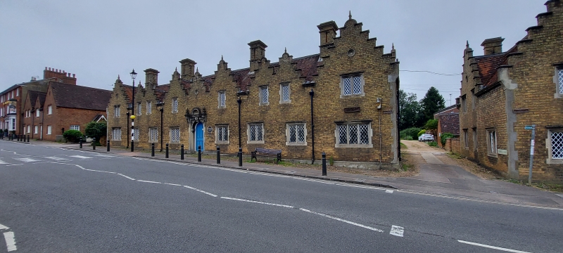
SP 9433-9533 MOBURN BEDFORD STREET (West Side)
8/94
- Staunton House (Nos 2 to 8
consecutive )
GV II
Almshouses, S part of the group formerly known as the Staunton Almshouses.
Dated 1850 above doorway. Founded 1635 by Sir Francis Staunton of Birchmore
in his will, and granted by Act of 1760 to John Duke of Bedford. These
buildings erected by Francis 7th Duke of Bedford. Yellow brick with rendered
dressings. Clay tile roofs. Rear blocks of red brick. Main part consists of
long rectangular block bordering pavement. 2 storeys. Loosely Jacobean in
style. Symmetrical road elevation has 9 crowstepped gables in various sizes,
outer ones largest. Ground floor has 6 2-light windows flanked by 2 3-light
windows. First floor has 6 single lights flanked by 2 2-light windows. All
are cast iron lattice casements set in mullioned openings, with square heads
and moulded dripstones. Central and outer gables each have small oculus to
apex with decorative grille. Central doorway contains 6-panel round-headed
door. This is set in round-arched opening in square surround. Large keystone
rises to modillion cornice which is flanked by ornamental volutes. Volutes
are surmounted by heavy moulded finials. Above centre of cornice is moulded
semi-circular panel containing date plaque. Substantial multiple ridge stacks
with Moulded caps. To rear, linked to main block by garden walls, is low
rectangular outhouse block. Red brick with clay tile roofs, in simpler but
similar style to main block. Symmetrical arrangement with central slightly
taller gable. flow converted to communal room for residents. Forms a pair
with item 8/93.
Listing NGR: SP9480433384
External links are from the relevant listing authority and, where applicable, Wikidata. Wikidata IDs may be related buildings as well as this specific building. If you want to add or update a link, you will need to do so by editing the Wikidata entry.


Other nearby listed buildings
