Approximate Location Map
Large Map »
Latitude: 54.8646 / 54°51'52"N
Longitude: -1.5584 / 1°33'30"W
OS Eastings: 428443
OS Northings: 552286
OS Grid: NZ284522
Mapcode National: GBR KDK5.DZ
Mapcode Global: WHC45.1Z6N
Plus Code: 9C6WVC7R+RM
Entry Name: Chester New Bridge
Listing Date: 23 February 1987
Grade: II*
Source: Historic England
Source ID: 1323102
English Heritage Legacy ID: 109347
ID on this website: 101323102
Location: County Durham, DH3
County: County Durham
Electoral Ward/Division: Lumley
Parish: Non Civil Parish
Traditional County: Durham
Lieutenancy Area (Ceremonial County): County Durham
Church of England Parish: Chester-le-Street
Church of England Diocese: Durham
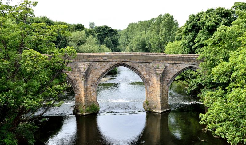
BOURNMOOR CHESTER ROAD
NZ 25 SE
(North side)
4/1 Chester New Bridge
II*
Single-track road bridge over the River Wear leading to south-west arched
gateway (q.v.) to Lambton Park. Probably C15; partly-rebuilt parapet. Dressed
stone.
Circa 45-metre span. Both faces similar. 4 pointed arches of 2 chamfered
orders; each arch on 5 chamfered ribs (some partly restored). Triangular-plan
cutwaters between arches (3 on each face); cutwaters have multi-chamfered
plinths, sloping tops and rise to parapet band. Slightly-projecting parapet
has restored coping and splayed north end walls. Large abutment with offsets
at north-west end.
This bridge straddles Chester-le-Street and the parish of Bournmoor.
(E. Jervoise, The Ancient Bridges of the North of England, 1973).
Listing NGR: NZ2844352286
External links are from the relevant listing authority and, where applicable, Wikidata. Wikidata IDs may be related buildings as well as this specific building. If you want to add or update a link, you will need to do so by editing the Wikidata entry.


Other nearby listed buildings
