Approximate Location Map
Large Map »
Latitude: 50.6293 / 50°37'45"N
Longitude: -2.1275 / 2°7'38"W
OS Eastings: 391078
OS Northings: 81073
OS Grid: SY910810
Mapcode National: GBR 227.GXX
Mapcode Global: FRA 67FD.WG9
Plus Code: 9C2VJVHF+P2
Entry Name: Farm Buildings South of Manor Farm House
Listing Date: 2 October 1984
Grade: II
Source: Historic England
Source ID: 1323380
English Heritage Legacy ID: 108703
ID on this website: 101323380
Location: Steeple, Dorset, BH20
County: Dorset
Civil Parish: Steeple with Tyneham
Traditional County: Dorset
Lieutenancy Area (Ceremonial County): Dorset
Church of England Parish: Steeple with Tyneham St Michael and All Angels
Church of England Diocese: Salisbury
Tagged with: Agricultural structure
SY98SW MORETON STEEPLE
9/246
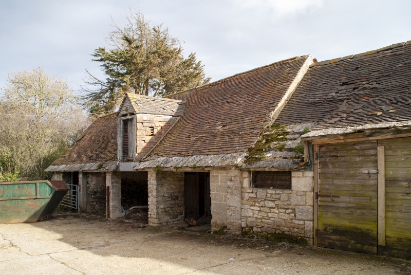
Farm buildings south
of Manor Farm House
GV
II
Range of farm buildings forming three sides of a courtyard. Probably mid C19.
Rubble stone walls, tiled roofs with stone eaves courses. Partly open-fronted
with stone piers. Solid sections have stable doors. Included for group value.
Listing NGR: SY9107881073
External links are from the relevant listing authority and, where applicable, Wikidata. Wikidata IDs may be related buildings as well as this specific building. If you want to add or update a link, you will need to do so by editing the Wikidata entry.


Other nearby listed buildings
