Approximate Location Map
Large Map »
Latitude: 50.6861 / 50°41'9"N
Longitude: -2.1091 / 2°6'32"W
OS Eastings: 392388
OS Northings: 87385
OS Grid: SY923873
Mapcode National: GBR 32T.TVJ
Mapcode Global: FRA 67G8.B56
Plus Code: 9C2VMVPR+C9
Entry Name: 8, East Street
Listing Date: 7 May 1952
Grade: II
Source: Historic England
Source ID: 1323576
English Heritage Legacy ID: 107960
ID on this website: 101323576
Location: Wareham, Dorset, BH20
County: Dorset
Civil Parish: Wareham Town
Built-Up Area: Wareham
Traditional County: Dorset
Lieutenancy Area (Ceremonial County): Dorset
Church of England Parish: Wareham Lady St Mary
Church of England Diocese: Salisbury
Tagged with: Building
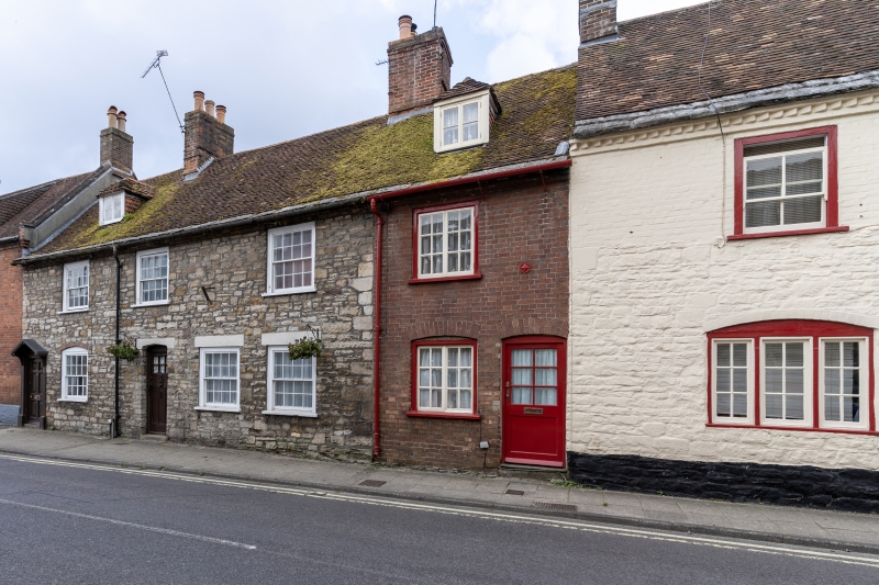
1.
5190 EAST STREET
(South Side)
No 8
SY 9287 1/58 7.5.52.
II GV
2.
C18. Red brick. Pitched tile roof. Red brick stack. 2 storeys and attic. Brick
oversailing courses at eaves. 1 range of casements with glazing bars. 1 flush-panelled
door. 1 attic dormer with hipped tile roof, tile-hung cheeks and casement. Badge
of the Lord of the Manor.
Nos 2 to 20 (even) form a group.
Listing NGR: SY9238987382
External links are from the relevant listing authority and, where applicable, Wikidata. Wikidata IDs may be related buildings as well as this specific building. If you want to add or update a link, you will need to do so by editing the Wikidata entry.


Other nearby listed buildings
