Latitude: 50.7701 / 50°46'12"N
Longitude: -2.2809 / 2°16'51"W
OS Eastings: 380289
OS Northings: 96764
OS Grid: SY802967
Mapcode National: GBR 0YZ.L5S
Mapcode Global: FRA 6731.P7H
Plus Code: 9C2VQPC9+3M
Entry Name: Barn About 400 Metres South of Manor Farm
Listing Date: 3 April 1998
Grade: II
Source: Historic England
Source ID: 1323736
English Heritage Legacy ID: 469169
ID on this website: 101323736
Location: Milborne St Andrew, Dorset, DT11
County: Dorset
Civil Parish: Milborne St. Andrew
Traditional County: Dorset
Lieutenancy Area (Ceremonial County): Dorset
Church of England Parish: Milborne St Andrew
Church of England Diocese: Salisbury
Tagged with: Barn
SY89NW MILBOURNE ST ANDREW
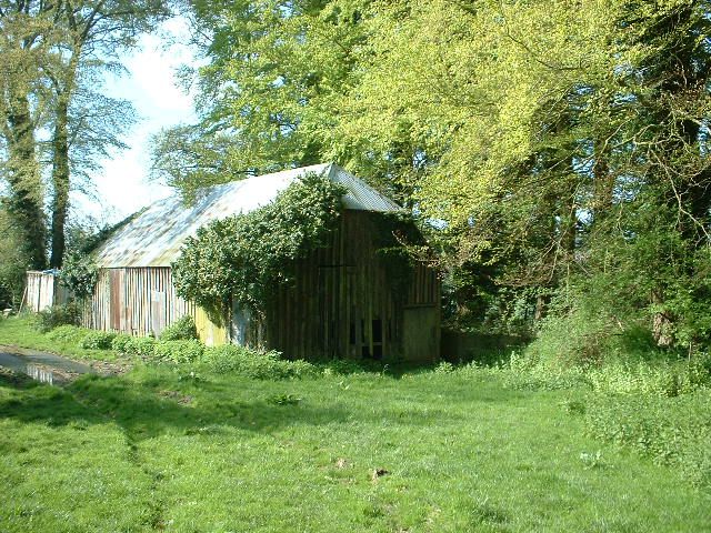
Barn about 400 metres south of
520/6/10000 Manor Farm
II
Barn. Circa early C19. Elm timber-frame clad in vertical boarding, and partly covered in corrugated sheet steel; the lower west side supported on staddle-stones. Corrugated sheet steel roof with half-hipped ends.
PLAN: Rectangular 8-bay frame; lower west side supported on staddle-stones. Later C19 waterwheel pit on west side.
EXTERIOR: Single storey. Cladding covers openings on east side. North end has double-doors on left and smaller door on right, both with plank doors. On west side later opening at centre for shaft to waterwheel [missing] , its brick and flint pit with head and tailrace remains.
INTERIOR: Small scanding 8-bay frame. The wall-posts have integral shaped brackets supporting arch-braces to col1ar-trusses with king-posts above, all bolted together and without carpentry joints. Purlins, principal and common-rafters intact. The wall-framing consists of rails and cross-bracing, onto which long studs are applied to the exterior. On the east side, blocked double doors in bay two from the north end, and loft doorway in bay six from the north end. At the centre of the west side a hole has been made for later machinery .
Listing NGR: SY8028996764
External links are from the relevant listing authority and, where applicable, Wikidata. Wikidata IDs may be related buildings as well as this specific building. If you want to add or update a link, you will need to do so by editing the Wikidata entry.


Other nearby listed buildings