Latitude: 50.7353 / 50°44'7"N
Longitude: -2.4837 / 2°29'1"W
OS Eastings: 365964
OS Northings: 92970
OS Grid: SY659929
Mapcode National: GBR PX.K1CT
Mapcode Global: FRA 57P4.G72
Plus Code: 9C2VPGP8+4G
Entry Name: Bradford Peverell Farmhouse
Listing Date: 26 January 1956
Grade: II
Source: Historic England
Source ID: 1324203
English Heritage Legacy ID: 105113
ID on this website: 101324203
Location: Bradford Peverell, Dorset, DT2
County: Dorset
Civil Parish: Bradford Peverell
Built-Up Area: Bradford Peverell
Traditional County: Dorset
Lieutenancy Area (Ceremonial County): Dorset
Church of England Parish: Bradford Peverell Church of the Assumption
Church of England Diocese: Salisbury
Tagged with: Farmhouse Thatched farmhouse
BRADFORD PEVERELL SY 69 SE BRADFORD PEVERELL VILLAGE
7/1 Bradford Peverell Farmhouse 26-1-56
GV II
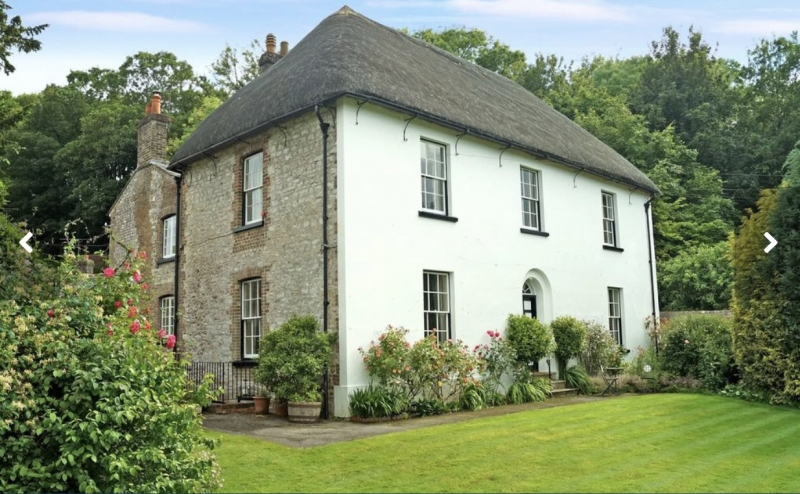
Detached Farmhouse. C18 rear range on lane, with early C19 front (west) block at right angles, and late C19 extension in the rear angle. Banded knapped flint and chalk block walls with stone quoins (rear range) with front of C19 block stuccoed and painted cream; brick quoins and dressings to the late C19 extension. Roofs: thatch to rear and front ranges, both hipped; slate roof to late C19 extension. Brick stacks, at south hip apex of front block, in valley at rear of front block, on north end wall of late C19, extension, all C19. On rear range, ridge, C20. Elevations, west (early C19), 2 storeys, 3 windows, sashes with glazing-bars (12 pane), stone cills, crown glass in bottom windows. Front door at centre, with a 6 rib-panel door, fanlight with variating glazing-bars over, moulded wooden frame. Sashes on north wall of this block have brick dressings and a segmental brick arch over. Rear range to lane. 2 storeys, 3 windows, 3-light wooden casements, with cills, C20. Top left is 3-light iron casement with lead lights. Door, left of centre, flush-panel with 2 upper lights C20. Main doorway in use, in rear angle, under pentice-roof extension, flush-panelled with 2 upper lights, C19.
Listing NGR: SY6596492970
External links are from the relevant listing authority and, where applicable, Wikidata. Wikidata IDs may be related buildings as well as this specific building. If you want to add or update a link, you will need to do so by editing the Wikidata entry.


Other nearby listed buildings