Latitude: 50.9218 / 50°55'18"N
Longitude: -2.3076 / 2°18'27"W
OS Eastings: 378472
OS Northings: 113641
OS Grid: ST784136
Mapcode National: GBR 0X5.5CP
Mapcode Global: FRA 661N.YLF
Plus Code: 9C2VWMCR+PW
Entry Name: Arched Causeway Adjoining Town Bridge
Listing Date: 20 October 1983
Grade: II
Source: Historic England
Source ID: 1324483
English Heritage Legacy ID: 102403
ID on this website: 101324483
Location: Newton, Dorset, DT10
County: Dorset
Civil Parish: Sturminster Newton
Traditional County: Dorset
Lieutenancy Area (Ceremonial County): Dorset
Church of England Parish: Sturminster Newton St Mary
Church of England Diocese: Salisbury
Tagged with: Bridge
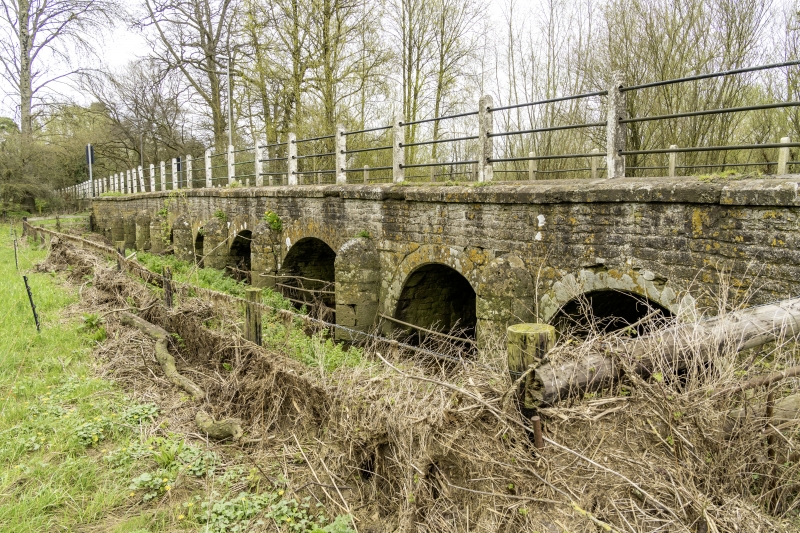
ST 7813 STURMINSTER NEWTON BRIDGE STREET
9/121 Arched Causeway
adjoining Town Bridge
G.V. II
Arched Causeway, C18. Coursed rubble and ashlar. 10 segmental arches with
ashlar voussoirs. Keel shaped cutwaters with rounded tops. Ashlar coping.
Forms a group with the Town Bridge and the bridge carrying the Blandford
road q.v. "RCHM, Dorset, Vol III", HMSO, 1970, p 271, no 3.
Listing NGR: ST7847213641
External links are from the relevant listing authority and, where applicable, Wikidata. Wikidata IDs may be related buildings as well as this specific building. If you want to add or update a link, you will need to do so by editing the Wikidata entry.


Other nearby listed buildings