Approximate Location Map
Large Map »
Latitude: 50.1178 / 50°7'4"N
Longitude: -5.5344 / 5°32'3"W
OS Eastings: 147438
OS Northings: 30175
OS Grid: SW474301
Mapcode National: GBR DXQC.MR6
Mapcode Global: VH12Z.191J
Plus Code: 9C2P4F98+47
Entry Name: 27, New Street
Listing Date: 7 February 1974
Grade: II
Source: Historic England
Source ID: 1327480
English Heritage Legacy ID: 69532
ID on this website: 101327480
Location: Penzance, Cornwall, TR18
County: Cornwall
Civil Parish: Penzance
Built-Up Area: Penzance
Traditional County: Cornwall
Lieutenancy Area (Ceremonial County): Cornwall
Church of England Parish: Penzance St Mary the Virgin with St Paul
Church of England Diocese: Truro
Tagged with: Building
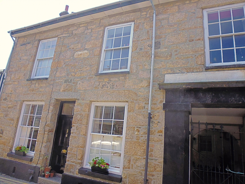
1.
1498 PENZANCE
NEW STREET
(South West Side)
No 27
SW 4730 5/530
II GV
2.
Early C19 house. Stucco. Slate roof with gable ends. Wide eaves soffit. 2
storeys. 3 windows, sashes with glazing bars. Plain doorway with rectangular
fanlight, to right carriageway with painted granite ashlar architrave and cornice.
Included for group value.
Nos 25 to 29 (consec) form a group.
Listing NGR: SW4743830175
External links are from the relevant listing authority and, where applicable, Wikidata. Wikidata IDs may be related buildings as well as this specific building. If you want to add or update a link, you will need to do so by editing the Wikidata entry.


Other nearby listed buildings
