Approximate Location Map
Large Map »
Latitude: 50.2171 / 50°13'1"N
Longitude: -5.2817 / 5°16'54"W
OS Eastings: 165984
OS Northings: 40384
OS Grid: SW659403
Mapcode National: GBR Z0.SFN1
Mapcode Global: VH12J.DSNY
Plus Code: 9C2P6P89+R8
Entry Name: Compresor House and Chimney Opposite Technical College Site
Listing Date: 7 April 1983
Grade: II
Source: Historic England
Source ID: 1328140
English Heritage Legacy ID: 66594
ID on this website: 101328140
CAMBORNE DOLCOATH ROAD
SW 64 SE
(south side)
Tuckingmill
5/48 Compressor house and chimney opposite
Technical College site
7.4.83
GV II
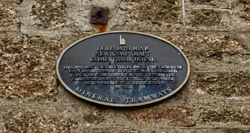
Compressor house and associated chimney stack, on site of New Sump
Shaft of former Dolcoath Mine. Probably late C19; altered. The compressor
house is of slobbered killas rubble with granite quoins and brick arches to
the openings, and scantle slate roof; the chimney of uncoursed granite
rubble with a short top stage of brick. The compressor house is a
rectangular single cell; the symmetrical facade has a wide round-headed
doorway flanked by tall round-headed windows, all with quoined jambs and
keyed brick heads, and an oculus above the doorway with keyed brick
surround; the side walls have 2 similar windows (boarded at time of
survey, 1988). Hipped roof with cockscomb tiles on the short ridge. A low
sloped extension at the back links to the west side of the chimney stack,
which is of tapered cylindrical form, with a short set-back brick stage
finished with a simple moulded cornice. History: New Sump Shaft was
Cornwall's deepest and richest tin mine, dating from at least as early as
1815, and eventually reaching a depth of 3000 feet. Reference: J.Trounson
Mining in Cornwall Vol.One (1980).
Listing NGR: SW6598440384
External links are from the relevant listing authority and, where applicable, Wikidata. Wikidata IDs may be related buildings as well as this specific building. If you want to add or update a link, you will need to do so by editing the Wikidata entry.


Other nearby listed buildings
