Approximate Location Map
Large Map »
Latitude: 50.3178 / 50°19'4"N
Longitude: -5.1978 / 5°11'51"W
OS Eastings: 172451
OS Northings: 51319
OS Grid: SW724513
Mapcode National: GBR Z4.K5RJ
Mapcode Global: FRA 0806.6VK
Plus Code: 9C2P8R92+4V
Entry Name: Wheal Kitty Engine House (Sara's Shaft) at SW724512
Listing Date: 31 October 1988
Grade: II
Source: Historic England
Source ID: 1328709
English Heritage Legacy ID: 63889
ID on this website: 101328709
Location: St Agnes, Cornwall, TR5
County: Cornwall
Civil Parish: St. Agnes
Traditional County: Cornwall
Lieutenancy Area (Ceremonial County): Cornwall
Church of England Parish: St Agnes
Church of England Diocese: Truro
Tagged with: Chimney
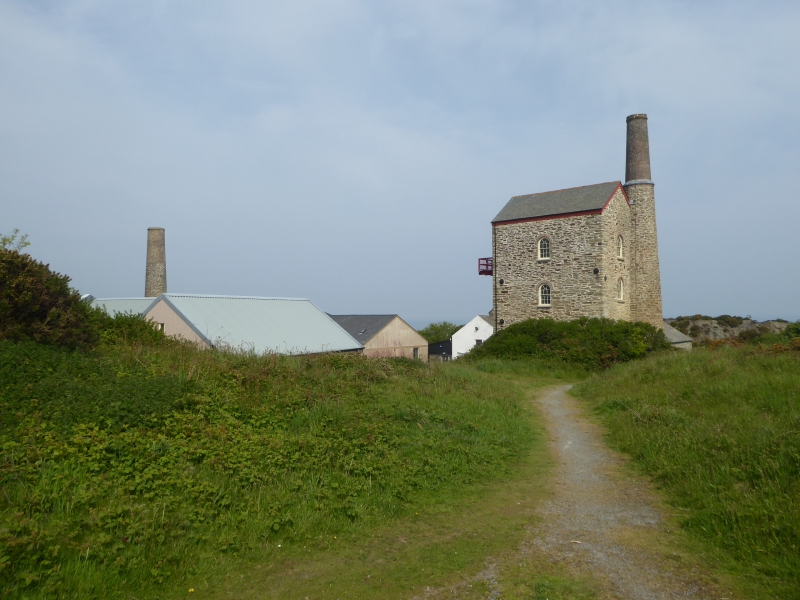
ST AGNES WHEAL KITTY
SW 75 SW
4/261 Wheal Kitty Engine House (Sara's
- Shaft) at SW724512
GV II
Pumping/winding beam engine house, including associated structures including
processing floors, all now disused. Circa mid-late C19. Slate killas walls. Brick
arches over the principal openings, timber lintels over the other openings. Brick
upper stage to chimney. Upper stage is stepped back.
Plan: Rectangular plan engine house with round chimney clasping the rear left-hand
corner. Associated dressing floors (possibly the most intact in Cornwall) nearby.
Exterior: 3 storeys. Unaltered and virtually complete elevations. Front (bob) wall
has central round-headed doorway. Rear gable end has large round-arched headed
doorway. Rear gable end has large round-arched cylinder doorway and 2 round-arched
window openings above. Right-hand (nearside) wall has 2 round-headed windows to
ground floor and similar openings midway to each upper floor. Left-hand (offside)
wall has round-headed doorway on the right and 3 small openings.
Interior: Not inspected.
Source: Sharpe, Adam and Smith, John. Engine Houses in St Agnes Parish. (Cornwall
Archaeological Unit survey for Carrick District Council.
Listing NGR: SW7240051200
External links are from the relevant listing authority and, where applicable, Wikidata. Wikidata IDs may be related buildings as well as this specific building. If you want to add or update a link, you will need to do so by editing the Wikidata entry.


Other nearby listed buildings
