Approximate Location Map
Large Map »
Latitude: 53.4057 / 53°24'20"N
Longitude: -2.5782 / 2°34'41"W
OS Eastings: 361654
OS Northings: 390035
OS Grid: SJ616900
Mapcode National: GBR BYF1.MV
Mapcode Global: WH98K.CNHG
Plus Code: 9C5VCC4C+7P
Entry Name: Barn to East of Orford Green Farmhouse
Listing Date: 4 April 1975
Grade: II
Source: Historic England
Source ID: 1329746
English Heritage Legacy ID: 58856
ID on this website: 101329746
Location: Warrington, Cheshire, WA2
County: Warrington
Electoral Ward/Division: Orford
Parish: Non Civil Parish
Built-Up Area: Warrington
Traditional County: Lancashire
Lieutenancy Area (Ceremonial County): Cheshire
Church of England Parish: Orford St Margaret
Church of England Diocese: Liverpool
Tagged with: Barn
VALE OWEN ROAD
1.
5150
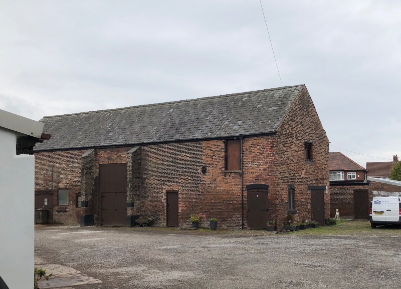
Barn to east of
Orford Green Farmhouse
SJ 6190 3/134
II GV
2.
Brick, probably early Cl9, slate roof, ventilation holes arranged in lozenges.
Segmental headed doorways to stable and shippon. Wing at rear.
Orford Green Farmhouse, Barn to East and Nos 1 to 3 (consec) Farm Cottages
form a group.
Listing NGR: SJ6165490035
External links are from the relevant listing authority and, where applicable, Wikidata. Wikidata IDs may be related buildings as well as this specific building. If you want to add or update a link, you will need to do so by editing the Wikidata entry.


Other nearby listed buildings
