Latitude: 53.1647 / 53°9'52"N
Longitude: -2.6389 / 2°38'19"W
OS Eastings: 357383
OS Northings: 363255
OS Grid: SJ573632
Mapcode National: GBR 7N.4MHN
Mapcode Global: WH99P.FQM7
Plus Code: 9C5V5976+VC
Entry Name: Well House Farmhouse
Listing Date: 3 January 1967
Last Amended: 14 February 1986
Grade: II
Source: Historic England
Source ID: 1330188
English Heritage Legacy ID: 57218
ID on this website: 101330188
Location: Eaton, Cheshire West and Chester, Cheshire, CW6
County: Cheshire West and Chester
Civil Parish: Rushton
Traditional County: Cheshire
Lieutenancy Area (Ceremonial County): Cheshire
Church of England Parish: Tarporley St Helen
Church of England Diocese: Chester
Tagged with: Farmhouse
SJ 56 SE RUSHTON C.P. EDGEWELL LANE
1/24 Well House Farmhouse (Formerly listed under 3.1.67 Well Lane)
GV II
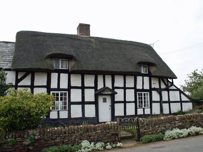
Farmhouse. Late C17. Timber framed with rendered infill. Baffle-entry plan, two storeys. Entrance front: 14 x 3 cells of small framing on a rendered stone plinth with angle braces to sides. Central doorway with gabled C19 porch. To either side are C19 2-light casement windows and there are swept 2-light dormers to the first floor with a central ridge chimney stack. Brick addition at left painted in simulation of timber-framing. Rear: 9 x 3 cells of small framing with angle braces at centre, a C19 and C20 block at the right and a projecting wing to the left with C19 and C20 windows. Interior: Ingle nook fireplace to parlour and chamfered ceiling beams to the parlour. The dining room has a 12-panel cut-down door and there is a bread-oven, approached from under the staircase built into the side of the hearth.
Listing NGR: SJ5738363255
External links are from the relevant listing authority and, where applicable, Wikidata. Wikidata IDs may be related buildings as well as this specific building. If you want to add or update a link, you will need to do so by editing the Wikidata entry.


Other nearby listed buildings