Approximate Location Map
Large Map »
Latitude: 51.6447 / 51°38'40"N
Longitude: -0.8027 / 0°48'9"W
OS Eastings: 482942
OS Northings: 194668
OS Grid: SU829946
Mapcode National: GBR D4W.V6S
Mapcode Global: VHDVY.1XHK
Plus Code: 9C3XJ5VW+VW
Entry Name: 52, High Street
Listing Date: 9 January 1954
Grade: II
Source: Historic England
Source ID: 1332362
English Heritage Legacy ID: 46088
ID on this website: 101332362
Location: West Wycombe, Buckinghamshire, HP14
County: Buckinghamshire
Civil Parish: West Wycombe
Traditional County: Buckinghamshire
Lieutenancy Area (Ceremonial County): Buckinghamshire
Church of England Parish: West Wycombe
Church of England Diocese: Oxford
Tagged with: Building
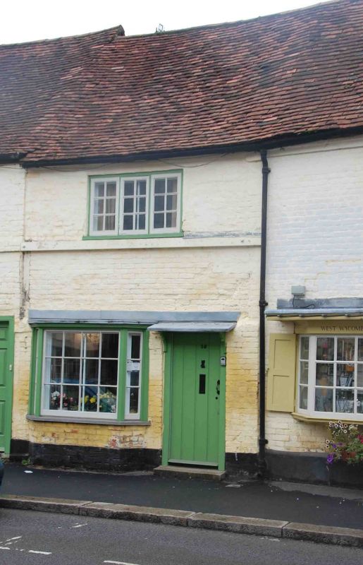
SU 8294 9/97
963
WEST WYCOMBE,
HIGH STREET (North Side),
No 52
9.1.54.
II GV
C18. Colour washed brick, old tiled roof. 2 storeys, ground floor canted
bay window and door under cut bracketed hood. 1st floor 3 light wooden
mullioned casement. Glazing bars to all windows. Graded for group value.
Listing NGR: SU8294094667
External links are from the relevant listing authority and, where applicable, Wikidata. Wikidata IDs may be related buildings as well as this specific building. If you want to add or update a link, you will need to do so by editing the Wikidata entry.


Other nearby listed buildings
