Approximate Location Map
Large Map »
Latitude: 51.629 / 51°37'44"N
Longitude: -0.7495 / 0°44'58"W
OS Eastings: 486649
OS Northings: 192986
OS Grid: SU866929
Mapcode National: GBR D54.WWB
Mapcode Global: VHDW4.YBM1
Plus Code: 9C3XJ7H2+J5
Entry Name: 12, High Street
Listing Date: 28 June 1973
Grade: II
Source: Historic England
Source ID: 1332374
English Heritage Legacy ID: 46043
ID on this website: 101332374
Location: High Wycombe, Buckinghamshire, HP11
County: Buckinghamshire
Electoral Ward/Division: Abbey
Parish: Non Civil Parish
Built-Up Area: High Wycombe
Traditional County: Buckinghamshire
Lieutenancy Area (Ceremonial County): Buckinghamshire
Church of England Parish: High Wycombe All Saints
Church of England Diocese: Oxford
Tagged with: Building
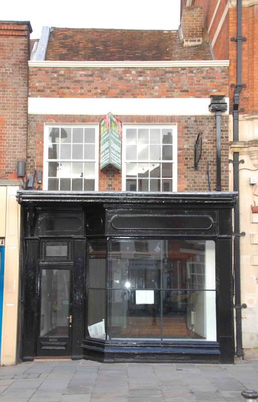
HIGH STREET
1.
963
(North Side)
No 12
SU 8692 NE 1/265
II
2.
C18 (business established, ? here, in 1775) front to probably earlier main
structure. Bell brick interspersed with mauve, Welsh slate roof. 2 storeys,
C19 shop front with widely spaced glazing bars, 2 1st floor sashes with
glazing bars in reveals and under flat arches. Stucco cornice band, parapet.
Listing NGR: SU8664992986
External links are from the relevant listing authority and, where applicable, Wikidata. Wikidata IDs may be related buildings as well as this specific building. If you want to add or update a link, you will need to do so by editing the Wikidata entry.


Other nearby listed buildings
