Approximate Location Map
Large Map »
Latitude: 50.8482 / 50°50'53"N
Longitude: -1.0266 / 1°1'35"W
OS Eastings: 468625
OS Northings: 105858
OS Grid: SU686058
Mapcode National: GBR BCL.R8L
Mapcode Global: FRA 86QV.RVJ
Plus Code: 9C2WRXXF+79
Entry Name: The Old Rectory
Listing Date: 30 October 1969
Grade: II
Source: Historic England
Source ID: 1333212
English Heritage Legacy ID: 474728
ID on this website: 101333212
Location: Farlington, Portsmouth, Hampshire, PO6
County: City of Portsmouth
Electoral Ward/Division: Drayton and Farlington
Parish: Non Civil Parish
Built-Up Area: Portsmouth
Traditional County: Hampshire
Lieutenancy Area (Ceremonial County): Hampshire
Church of England Parish: Farlington St Andrew
Church of England Diocese: Portsmouth
Tagged with: Clergy house
PORTSMOUTH
SU60NE HAVANT ROAD, Farlington
774-1/2/167 (North side)
30/10/69 Nos.353 AND 355
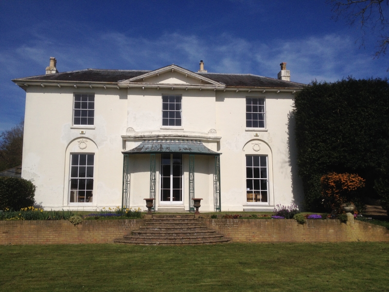
The Old Rectory
II
Villa. c1825. Stuccoed. Welsh slate hipped roof, rendered
stack to left and right.
2 storeys, attic to rear, 3 bays, centre bay projects. Facing
Havant Road at centre is a 2-leaf margin glazed French
casement set within shallow bow with projecting trellised
verandah with tented roof, cornice and blocking course with
rounded terminal caps. On left and right is a 12-pane sash
each set in round-headed recess with wreath ornamentation in
tympanum. On first floor are three 12-pane sashes, projecting
bracketed eaves. Centre bay has facing pediment. On right
return, 6 bays wide, are 2 blinded windows, then a 6-panelled
door with radial glazed fanlight set under segmental arch;
open projecting porch with segmented arches, pilasters and
square columns, cornice and blocking course; on right two
12-pane sashes. Left return also has entrance with segmental
headed porch.
INTERIOR not inspected.
(Lloyd DW: Buildings of Portsmouth and its Environs:
Portsmouth: 1974-: 116; The Buildings of England: Pevsner N &
Lloyd DW: Hampshire and the Isle of Wight: Harmondsworth:
1967-: 467).
Listing NGR: SU6862005851
External links are from the relevant listing authority and, where applicable, Wikidata. Wikidata IDs may be related buildings as well as this specific building. If you want to add or update a link, you will need to do so by editing the Wikidata entry.


Other nearby listed buildings
