Approximate Location Map
Large Map »
Latitude: 51.9126 / 51°54'45"N
Longitude: -2.0703 / 2°4'12"W
OS Eastings: 395262
OS Northings: 223792
OS Grid: SO952237
Mapcode National: GBR 2M4.5DB
Mapcode Global: VHB1Q.26D3
Plus Code: 9C3VWW7H+3V
Entry Name: The Grange
Listing Date: 5 May 1972
Last Amended: 26 November 1998
Grade: II
Source: Historic England
Source ID: 1333232
English Heritage Legacy ID: 474613
ID on this website: 101333232
Location: Pittville, Cheltenham, Gloucestershire, GL50
County: Gloucestershire
District: Cheltenham
Electoral Ward/Division: Pittville
Parish: Non Civil Parish
Built-Up Area: Cheltenham
Traditional County: Gloucestershire
Lieutenancy Area (Ceremonial County): Gloucestershire
Church of England Parish: Prestbury St Mary
Church of England Diocese: Gloucester
Tagged with: Building
CHELTENHAM
SO92SE EVESHAM ROAD
630-1/2/317 (West side)
05/05/72 The Grange, Nos.1-4 (even)
(Formerly Listed as:
EVESHAM ROAD
(West side)
The Grange)
II
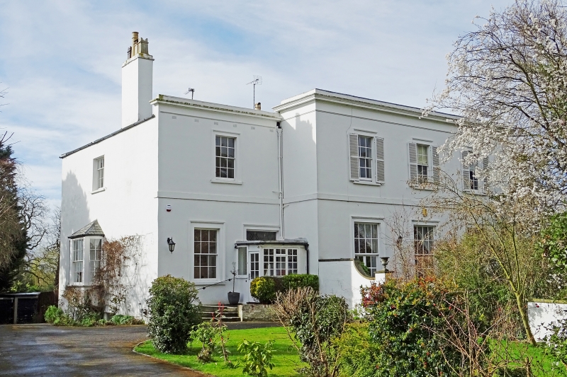
Villa, now 4 dwellings. c1830s. Stucco over brick with
concealed roof with tall left end stack.
EXTERIOR: 2 storeys, 5 first-floor windows arranged 1:3:1.
Stucco detailing includes first-floor band, frieze and
cornice, windows in tooled architraves. Central 3 window-range
breaks forward. Ground floor, at centre has two 8/8 sashes and
8/French window, otherwise mainly 6/6 sashes throughout, those
to ground floor are taller; external louvred shutters with
shutter latches. To right at ground floor a C20 canted bay.
Entrances: to left at angle a glazed C20 porch. Further
entrance to right return, a C20 panelled door.
INTERIOR: not inspected.
Listing NGR: SO9525323802
External links are from the relevant listing authority and, where applicable, Wikidata. Wikidata IDs may be related buildings as well as this specific building. If you want to add or update a link, you will need to do so by editing the Wikidata entry.


Other nearby listed buildings
