Approximate Location Map
Large Map »
Latitude: 53.3239 / 53°19'26"N
Longitude: -1.4047 / 1°24'16"W
OS Eastings: 439750
OS Northings: 380943
OS Grid: SK397809
Mapcode National: GBR LZM0.P5
Mapcode Global: WHDDX.DQB5
Plus Code: 9C5W8HFW+H4
Entry Name: Litfield Farmhouse and Attached Outbuildings to West
Listing Date: 1 August 1975
Last Amended: 7 July 1989
Grade: II
Source: Historic England
Source ID: 1335079
English Heritage Legacy ID: 79600
Also known as: Litfield Farm
ID on this website: 101335079
Location: Ridgeway, North East Derbyshire, S12
County: Derbyshire
District: North East Derbyshire
Civil Parish: Eckington
Traditional County: Derbyshire
Lieutenancy Area (Ceremonial County): Derbyshire
Church of England Parish: Eckington and Ridgeway
Church of England Diocese: Derby
Tagged with: Farmhouse
PARISH OF ECKINGTON SLOAD LANE
SK 38 SE
1/119
Litfield Farmhouse
1.8.75 and attached
outbuildings to
west (formerly
listed as Litfield
Farmhouse)
II
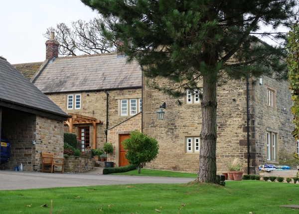
Farmhouse and attached outbuilding. C17 with C18 additions and
C19 alterations. Coursed rubble coal measures sandstone with
quoins, coped gables with moulded kneelers, brick ridge stacks,
Welsh and stone slated roof. Irregular L-plan with gabled
crosswing to east end, advanced, and a second gabled wing to the
north. To the west the house adjoins an open-fronted
outbuilding which itself has a gabled projection to the rear.
Farmhouse. South elevation. Two storeys, four bays that to the
east the advanced wing. Main range with stacked 3-light flush
mullioned windows to the west of the main door, in the angle of
the two ranges, and a single light window over the door. A
second doorway with quoined surround and a 2-light flush
mullioned windows are situated at the west end, where the house
adjoins the outbuilding. The gable of the advanced range has a
2-light chamfer mullioned windows to the first floor, and a C19
enlarged openings to the ground floor, together with a low coped
parapet. The north gable has a 2-light flush mullioned window
beneath a dripmould to the attic floor, an advanced gable to the
west and a 3 and a 4-light chamfer mullioned window with
dripmoulds and a 3-light chamfer mullioned window to the north
wall of the main range. Attached outbuilding, to the west an
irregular T-plan with the section adjoining the house having two
openings with segmental brick arches. At the west end an
advanced single storey three bay wing with two doorways, each
with chamfered quoined surround, and an inserted full-height
double opening beneath a stone slated roof. A two bay range
with an opening in the north gable projects to the rear of the
main range.
Listing NGR: SK3975080943
External links are from the relevant listing authority and, where applicable, Wikidata. Wikidata IDs may be related buildings as well as this specific building. If you want to add or update a link, you will need to do so by editing the Wikidata entry.


Other nearby listed buildings
