Latitude: 54.3501 / 54°21'0"N
Longitude: -2.716 / 2°42'57"W
OS Eastings: 353559
OS Northings: 495182
OS Grid: SD535951
Mapcode National: GBR 9LG4.SD
Mapcode Global: WH82Q.7XYK
Plus Code: 9C6V972M+2J
Entry Name: Laverock Bridge
Listing Date: 21 November 1952
Grade: II
Source: Historic England
Source ID: 1335957
English Heritage Legacy ID: 75743
ID on this website: 101335957
Location: Meal Bank, Westmorland and Furness, Cumbria, LA9
County: Cumbria
District: South Lakeland
Civil Parish: Skelsmergh and Scalthwaiterigg
Traditional County: Westmorland
Lieutenancy Area (Ceremonial County): Cumbria
Church of England Parish: Skelsmergh St John the Baptist
Church of England Diocese: Carlisle
Tagged with: Bridge
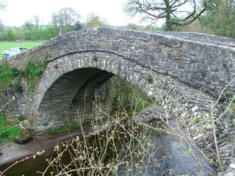
SD 59 NW SCALTHWAITERIGG MEALBANK ROAD
6/163
Laverock Bridge
21.11.52
II
Bridge over river Mint. Probably C17 or C18, later widening to east, and
parapets. Segmental arch and band; low parapets. Abutments curve out. Roadway
is approx. 3m wide.
Listing NGR: SD5355995182
External links are from the relevant listing authority and, where applicable, Wikidata. Wikidata IDs may be related buildings as well as this specific building. If you want to add or update a link, you will need to do so by editing the Wikidata entry.


Other nearby listed buildings