Approximate Location Map
Large Map »
Latitude: 54.2324 / 54°13'56"N
Longitude: -3.1866 / 3°11'11"W
OS Eastings: 322752
OS Northings: 482504
OS Grid: SD227825
Mapcode National: GBR 6M5H.XK
Mapcode Global: WH71Y.0WW7
Plus Code: 9C6R6RJ7+X9
Entry Name: Barn Opposite Ship Inn
Listing Date: 8 November 1984
Grade: II
Source: Historic England
Source ID: 1335964
English Heritage Legacy ID: 75871
ID on this website: 101335964
Location: Sand Side, Westmorland and Furness, Cumbria, LA17
County: Cumbria
District: South Lakeland
Civil Parish: Kirkby Ireleth
Built-Up Area: Kirkby-in-Furness
Traditional County: Lancashire
Lieutenancy Area (Ceremonial County): Cumbria
Church of England Parish: Kirkby Ireleth St Cuthbert
Church of England Diocese: Carlisle
Tagged with: Barn
This List entry was subject to a Minor Amendment on 28/03/2017
SD 28 SW,
12/97
KIRKBY IRELETH,
SAND SIDE,
Barn opposite Ship Inn
08.11.84
II
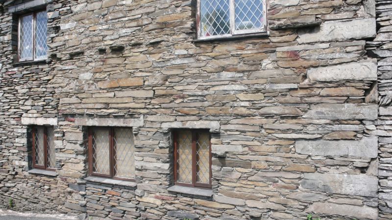
Two barns at right angles and stable. (Noted residential 03/2017.)
Early to mid C18 west barn and early to
mid C19 east barn, end stable, later additions. Slate rubble with quoins.
East barn with through stones, west barn on boulder plinth; slate roofs.
Boarded doors, slits and small square vents. South elevation has two windows,
one later, flanking entrance with pitching eye over to east barn, earlier
west barn has steeper roof pitch and blocked loading door. West elevation
has lean-to cow house and waggon entrance. South end is cow house with loft
over, to north a C19 stable wing. North elevation of west barn is roughcast
with roofless lean-to projection; east elevation has entrance. West barn
has later lean-to stable partly blocking large entrance with pitching hole
above.
INTERIORS: the older 4-bay barn has pegged principal-rafter trusses
with two tiers of purlins; two tie beams replaced. Shippon has old slate-slab
partitions in pegged frames. East barn and stable to west have C19 trusses.
A notable feature of this building is the inscriptions in good late Georgian
style, some dated 1879, similar to those on Wreaks Causeway End bridge (q.v.)
and local buildings. West barn south-west elevation has direction signs;
"BROUGHTON" and "ULVERSTON/5 ML". Others to south and east elevations of
barns, west stable and east stable said to be names of stallions standing at
stud at the Ship Inn and their owners, e.g. "JOHN GRAHAM/& TOPSMAN",
"GALLOWAY JACK"; others: "THE/CHARMING MONTH/OF MAY", "DREARY WINTER",
"COME AND TURN THE HANDLE", are similar to those on Wreaks Causeway End
bridge.
Listing NGR: SD2275282504
External links are from the relevant listing authority and, where applicable, Wikidata. Wikidata IDs may be related buildings as well as this specific building. If you want to add or update a link, you will need to do so by editing the Wikidata entry.


Other nearby listed buildings
