Latitude: 54.3799 / 54°22'47"N
Longitude: -2.8543 / 2°51'15"W
OS Eastings: 344607
OS Northings: 498604
OS Grid: SD446986
Mapcode National: GBR 8KHS.VP
Mapcode Global: WH82N.452M
Plus Code: 9C6V94HW+X7
Entry Name: Ings School
Listing Date: 14 August 1984
Grade: II
Source: Historic England
Source ID: 1336078
English Heritage Legacy ID: 76471
ID on this website: 101336078
Location: Ings, Westmorland and Furness, Cumbria, LA8
County: Cumbria
District: South Lakeland
Civil Parish: Hugill
Traditional County: Westmorland
Lieutenancy Area (Ceremonial County): Cumbria
Church of England Parish: Hugill or Ings St Anne
Church of England Diocese: Carlisle
Tagged with: School building
SD 49 NW HUGILL Ings
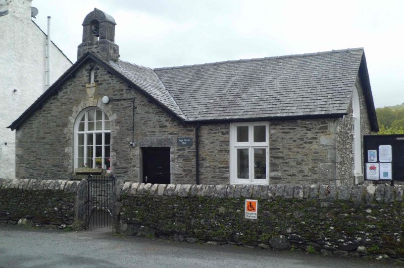
5/19 Ings School
G.V. II
School; now Parish Hall, dated 1869. Stone rubble walls; roughcut quoins;
limestone cills and dressings; graduated greenslate roof; blue glazed ridge.
L-shaped plan with gable to road at left. Single storey. Round-arched
casement with glazing bars and 2 tiny round-headed windows above in gable; cross
casement to right; boarded door between. Other elevations show 2 similar round-
arched casements; 2 similar cross windows on left return. Bellcote on front
gable. Interior retains pine boarded dado and original boarded doors.
Listing NGR: SD4460798604
External links are from the relevant listing authority and, where applicable, Wikidata. Wikidata IDs may be related buildings as well as this specific building. If you want to add or update a link, you will need to do so by editing the Wikidata entry.


Other nearby listed buildings