Approximate Location Map
Large Map »
Latitude: 51.2713 / 51°16'16"N
Longitude: 0.5221 / 0°31'19"E
OS Eastings: 576032
OS Northings: 155481
OS Grid: TQ760554
Mapcode National: GBR PR7.6TF
Mapcode Global: VHJMF.09DS
Plus Code: 9F327GCC+GV
Entry Name: The Tithe Barn
Listing Date: 30 July 1951
Grade: I
Source: Historic England
Source ID: 1336233
English Heritage Legacy ID: 173438
ID on this website: 101336233
Location: Maidstone, Kent, ME15
County: Kent
District: Maidstone
Electoral Ward/Division: High Street
Parish: Non Civil Parish
Built-Up Area: Maidstone
Traditional County: Kent
Lieutenancy Area (Ceremonial County): Kent
Tagged with: Museum building
This list entry was subject to a Minor Amendment on 28/02/2017
TQ 7655 NW 2/69
TQ 7655 SW 7/69
MILL STREET (West Side)
Tyrwhitt Drake Museum of Carriages
The Tithe Barn
(Formerly listed as The Tithe Barn (Archbishop's Stables or Carriage Museum) Mill Street)
30.7.51
GV
I
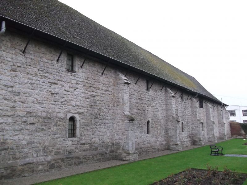
A large C14 Tithe barn which was subsequently used as the stables of the Archbishop's
Palace. It is now The Tyrwhitt Drake Museum of Carriages. Two storeys stone rubble. Hipped tiled roof, six bays with a buttress between each. The east front has six small narrow windows on each floor. The west front has five obtusely-pointed doorways (Two of them larger than the others) and a two-storeyed porch in the centre. The ground floor of the porch is of stone. Its first floor is timbered with modern brick infilling and projects on the protruding ends of the floor joists and brackets. It has a double loft door with a flight of stone steps leading up to it on the north side of the porch and a gable over. The west front also has five small windows on the first floor and one other doorway. Crown-post roof inside. Scheduled as an AM.
Gateway and Wall to Palace Gardens, Wall to north west of Archbishop's Palace, The Archbishop's Palace, Wall to east of Archbishop's Palace, The Dungeons at the Archbishop's Palace, The Gate House at the Archbishop's Palace, The Len Bridge, The Tithe Barn, Parish Church of All Saints, Wall to north and west of All Saints Church, The College Gateway, The College Tower, The Master's House, The Master's Tower, Cutbush Almshouses and the Ruined Gateway form a group.
Listing NGR: TQ7597455470
External links are from the relevant listing authority and, where applicable, Wikidata. Wikidata IDs may be related buildings as well as this specific building. If you want to add or update a link, you will need to do so by editing the Wikidata entry.


Other nearby listed buildings
