Approximate Location Map
Large Map »
Latitude: 51.6271 / 51°37'37"N
Longitude: 0.8178 / 0°49'4"E
OS Eastings: 595131
OS Northings: 195792
OS Grid: TQ951957
Mapcode National: GBR RPT.X62
Mapcode Global: VHKH9.4C6J
Plus Code: 9F32JRG9+R4
Entry Name: 22-28, Chapel Road
Listing Date: 27 January 1975
Grade: II
Source: Historic England
Source ID: 1337654
English Heritage Legacy ID: 116579
ID on this website: 101337654
Location: Burnham-on-Crouch, Maldon, Essex, CM0
County: Essex
District: Maldon
Civil Parish: Burnham-on-Crouch
Built-Up Area: Burnham-on-Crouch
Traditional County: Essex
Lieutenancy Area (Ceremonial County): Essex
Church of England Parish: Burnham-on-Crouch St Mary the Virgin
Church of England Diocese: Chelmsford
Tagged with: Building
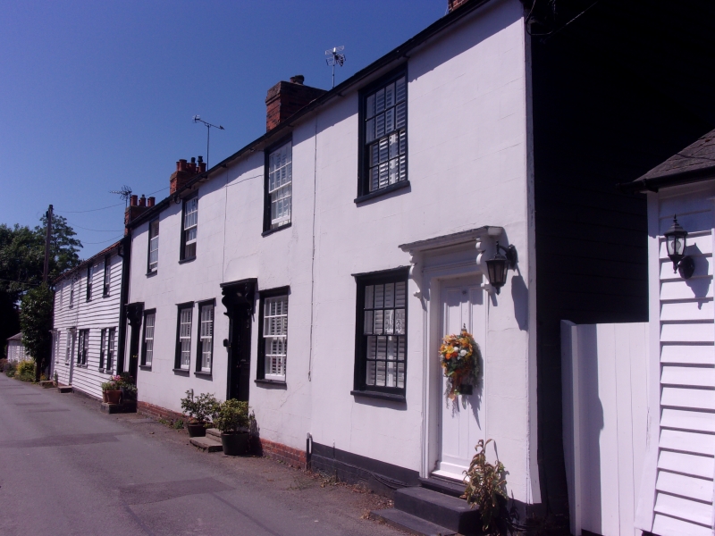
CHAPEL ROAD
1.
5217
Nos 22 to 28 (even)
TQ 9595 1/59
II GV
2.
A range of early-mid C19 timber-framed and plastered houses. 2 storeys.
4 window range, double-hung sashes with glazing bars. 4-panel doors with
shallow hoods on shaped brackets. Roofs slate. (A typical, range of
this period).
Nos 8to 32 (even) form a group.
Listing NGR: TQ9512595799
External links are from the relevant listing authority and, where applicable, Wikidata. Wikidata IDs may be related buildings as well as this specific building. If you want to add or update a link, you will need to do so by editing the Wikidata entry.


Other nearby listed buildings
